
(10:00PM EST – promoted by Nightprowlkitty)
This is going to be short but might be helpful to some for a wide variety of reasons.
Google has teamed up with GeoEye to bring updated aerial views of the devastation from the Haiti Earthquake.
Google Earth Reveals the Devastation in Haiti
Google responded to the devastating earthquake that hit Haiti earlier this week by working with satellite imagery company GeoEye to quickly make images of the destruction available in Google Earth and Google Maps. The images were taken at approximately 10:27 AM Eastern time on Wednesday, and could prove to be a helpful tool for aid organizations attempting to survey and assess the damage to Haiti’s infrastructure.
They have backlinks to explain at the site.
Google says it will automatically update the Haiti layer as more data and images become available, but Google Earth users only need to download the KML file once.
If you are Haitian American, or have friends there, or may not know anyone but find you could use this as to follow the reports etc.
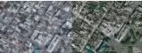
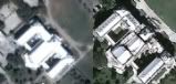
The best way to understand the devastation is to compare before and after images by switching the Haitian layer on and off….>>>>>
I haven’t tried this yet, just came across it. There are a few pictures with report that can be enlarged and viewed.
If you’re in an agency og group planning on going, or know some others who are you might find this useful to keep track or if going to understand better to plan.
Here are two of the photo’s, side by side before and after, Google has on the link above, click on them for their enlarged view.
Haiti Neighborhood
Haiti’s National Palace
Google Blog post from yesterday
Imagery & maps in the wake of the Haiti Earthquake
Yesterday a 7.0 magnitude earthquake struck Haiti, causing significant destruction and devastation. Since then, we’ve received numerous requests from relief organizations and our users to share recent satellite imagery of the country. One of our imagery partners, GeoEye, has just provided us with post-earthquake imagery from Haiti. We’re working on making it available as a KML overlay in Google Earth as soon as possible; in the meantime, here is snapshot of the imagery we’ll be providing. The image was taken at approximately 10:27am Eastern today and this photo shows Port-au-Prince.
We will update this blog post as soon as the layer is available….>>>>>
4 comments
Skip to comment form
Author
Earthquakes have long term health effects
This is one reason many of us have been advocates and activist for so many years, it isn’t only for our brothers and sisters of ‘Nam and other Wars, it’s also to wake up the civilian World Populations as to what happens to many after their own extremely traumatic life experiences. Wars and Occupations by nature are 24/7 stresses for all involved, including the residents of the countries especially, and by researching the soldiers and civilians of we could have learned so much before and over these last decades!!