
(9AM EST – promoted by Nightprowlkitty)
2011 marks the sesquicentennial of the start of the American Civil War. On New Year’s Day 150 years ago, South Carolina had already seceded from the United States and the next months would see ten more states secede from the Union, the inauguration of Abraham Lincoln, the formation of the Confederate States of America, and the start of the war.
Historian Susan Schulten wrote about the 1860 Census and map showing American slavery in The New York Times last month. The United States Coast Survey used the 1860 Census data, the last time the federal government counted the slave population, to produce two maps illustrating slave population – one of Virginia and the other of the entire South.
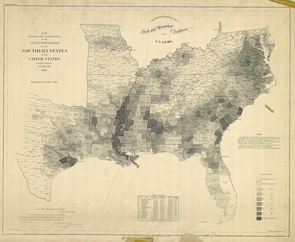
The map depicts each county’s slave population, with “the darker the shading, the higher the number of slaves”, which is a “visually arresting way to see the range of slavery across the South without having to read a single data point,” she writes. It was popular with President Lincoln and the American public after its publication. It was sold throughout the war “for the benefit of the sick and wounded soldiers.”
The map reaffirmed the belief of many in the Union that secession was driven not by a notion of “state rights,” but by the defense of a labor system. A table at the lower edge of the map measured each state’s slave population, and contemporaries would have immediately noticed that this corresponded closely to the order of secession. South Carolina, which led the rebellion, was one of two states which enslaved a majority of its population, a fact starkly represented on the map.
From this map’s black-and-white shadings, Americans could see the cause of the war and the entrenchment of slavery in the South. More than 80 percent of the people were enslaved in Beaufort County, South Carolina, the home of secessionist Robert Rhett, and the number of slaves in Texas tripled between 1850 and 1860, for instance. “The map gave a clear picture of what the Union was up against, and allowed Northerners to follow the progress of the war and the liberation of slave populations,” Schulten writes.
|
Fighting for “Southern Rights“…
|
or owning slaves.
|
The cotton-producing counties along the Mississippi River and the rice and cotton-growing areas in South Carolina are “almost black”, and parts of Kentucky and the Appalachians are “nearly white”. This map, I think, helps explain why Kentucky initially declared itself neutral and why the Appalachian western part of Virginia seceded from the state and rejoined the Union in 1863.
“Though many Americans knew that dependence on slave labor varied throughout the South, these maps uniquely captured the complexity of the institution and struck a chord with a public hungry for information about the rebellion,” she writes.
Lincoln used this map to focus on “the Confederacy’s greatest asset: its labor system” and it was immortalized in a painting by Francis Bicknell Carpenter of the president and his Cabinet reading the Emancipation Proclamation, which freed the 3.1 million people enslaved in the Confederate States.
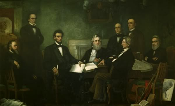
The map can be seen in the bottom right hand corner of the 1864 painting “First Reading of the Emancipation Proclamation of President Lincoln” by Francis Bicknell Carpenter. |
Schulten writes:
Carpenter spent the first six months of 1864 in the White House preparing the portrait, and on more than one occasion found Lincoln poring over the map… Lincoln was enthusiastic about Carpenter’s finished portrait, and singled out the map as one of its most notable details.
As we enter in the next four years remembering the 150th anniversary of the American Civil War and the inevitable attempts of revisionism, maps like this I think are important in underscoring a true cause to why our Southern states left the Union and why many in the North fought to end the institution of slavery.
Cross-posted from Daily Kos.
8 comments
Skip to comment form
Author
of Issaquena County, Mississippi was enslaved in 1860.
corpo-fascism slave one.