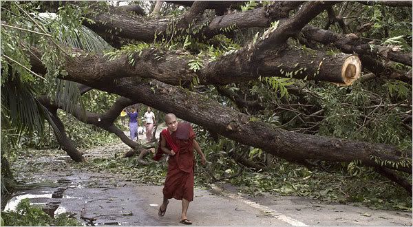
As if the devastation from Cyclone Nargis on May 3 was not enough. As if the inability of the government to help the victims or allow international aid organizations to feed and shelter the millions in need was not enough. As if the people of Myanmar had not suffered enough death, disease, hunger, thirst, cold, and fear. An estimated 2 million survivors of the storm are still in need of emergency aid. To date, U.N. agencies and other groups have been able to reach only 270,000 people.
Bottlenecks, poor logistics, limited infrastructure and the military government’s refusal to allow foreign aid workers have left most of the delta’s survivors living in miserable conditions without food or clean water. The government’s efforts have been criticized as woefully slow.
The situation is about to get much, much worse. Forecasters are now tracking another tropical low that is expected to become another cyclone and track into the already devastated Irriwaddy delta.
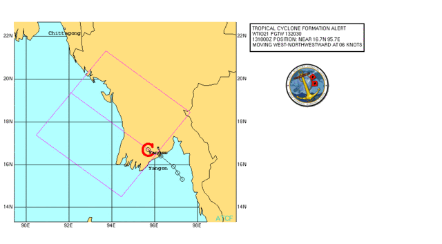
Here is the projected storm path from the U.S. military’s Joint Typhoon Warning Center:
Here is the text of the current forecast warning:
1. FORMATION OF A SIGNIFICANT TROPICAL CYCLONE IS POSSIBLE WITHIN
150 NM EITHER SIDE OF A LINE FROM 16.5N 96.1E TO 19.4N 92.1E
WITHIN THE NEXT 12 TO 24 HOURS. AVAILABLE DATA DOES NOT JUSTIFY
ISSUANCE OF NUMBERED TROPICAL CYCLONE WARNINGS AT THIS TIME.
WINDS IN THE AREA ARE ESTIMATED TO BE 25 TO 30 KNOTS. METSAT IM-
AGERY AT 131800Z INDICATES THAT A CIRCULATION CENTER IS LOCATED
NEAR 16.7N 95.7E. THE SYSTEM IS MOVING WEST-NORTHWESTWARD AT 06
KNOTS.2. REMARKS:
RECENT ANIMATED INFRARED SATELLITE IMAGERY AND A 121210Z SSMI
MICROWAVE IMAGE INDICATE PRONOUNCED LOW-LEVEL CYCLONIC TURNING
OF CONVECTION AT THE WESTERN END OF THE MONSOON TROUGH. HOWEVER,
MORE RECENTLY, CONVECTION HAS WANED SOMEWHAT IN RESPONSE TO LAND
INTERACTION. THE CIRCULATION CENTER IS CURRENTLY TRANSITING
GENERALLY NORTHWESTWARD ACROSS THE YANGON DELTA REGION OF MYANMAR.
OBSERVATIONS FROM YANGON AS OF 131300Z, SUPPORT A 25 TO 30 KNOT
CIRCULATION WITH SEA LEVEL PRESSURES NEAR 1000 MB (3 MB PRESSURE
FALLS OVER THE PAST 24 HOURS) AND SUSTAINED WINDS AT 10 KNOTS
GUSTING TO 20 KNOTS OUT OF THE NORTHEAST. A PARTIAL 130301Z ASCAT
IMAGE ALSO INDICATES STRONG WESTERLIES TO THE SOUTH OF THE
CENTER WITH SUSTAINED EASTERLIES TO THE NORTH, FURTHER PROOF OF
CYCLONIC TURNING. THE CENTER CURRENTLY LIES UNDER LOW VERTICAL
WIND SHEAR JUST SOUTH OF THE SUBTROPICAL RIDGE AXIS WITH FAVOR-
ABLE SOUTHWESTERLY DIFFLUENCE ALOFT. THOUGH THE DISTURBANCE IS
CURRENTLY OVER LAND, MINIMAL DEGRADATION OF THE LOW LEVEL IS
EXPECTED DUE TO THE LOW LYING TOPOGRAPHY AND FAIRLY QUICK TRANSIT
OVER THE LOW-LYING COASTAL REGION OF SOUTHERN MYANMAR. EMERGENCE
INTO THE BAY OF BENGAL IS EXPECTED WITHIN THE NEXT 12 TO 18 HOURS.
MAXIMUM SUSTAINED SURFACE WINDS ARE ESTIMATED AT 25 TO 30 KNOTS.
MINIMUM SEA LEVEL PRESSURE IS ESTIMATED TO BE NEAR 1000 MB. THE
POTENTIAL FOR THE DEVELOPMENT OF A SIGNIFICANT TROPICAL CYCLONE
WITHIN THE NEXT 24 HOURS IS GOOD WITH THE ONLY LIMITATION BEING
TEMPORARY LAND INTERACTION.
From a Burmese blogger:
Aw! Dukha Dukha Dukha
Life is all about suffering
at least I still have my place on earth
My neighbors are worse than me
We just have to live on
suffer and struggle
This is what Life is all about!
Help comes or not I do not mind
My life depends upon my own Karma
Help if you can
Food: World Food Programme
Relief supplies: International Committee of the Red Cross
Medicine: Doctors without Borders
Note: All aid organizations are reporting fraud. Give directly to the organization, not secondary sites or emails.


1 comments
Author
Thanks for reading. Please keep the people of Myanmar in your thoughts, prayers, and hearts.
Posted by May Burma at 4:52 AM 0 comments