( – promoted by buhdydharma )
The data just keep pouring in (quite literally,) on ice-melting around the world.
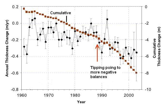
Most people have focused their attention on Arctic sea-ice melt, but the heating of the water and the air that is driving the breakup of Arctic ice shelves is also taking down all of the regions ice sheets as well. Similarly, increased melt rates have been noted in Greenland and Antarctica, while mountain glaciers are also losing mass at unprecedented rates. See chart below:
There can be no doubt that we are now past the tipping point for ice melt worldwide.
First the sea ice.
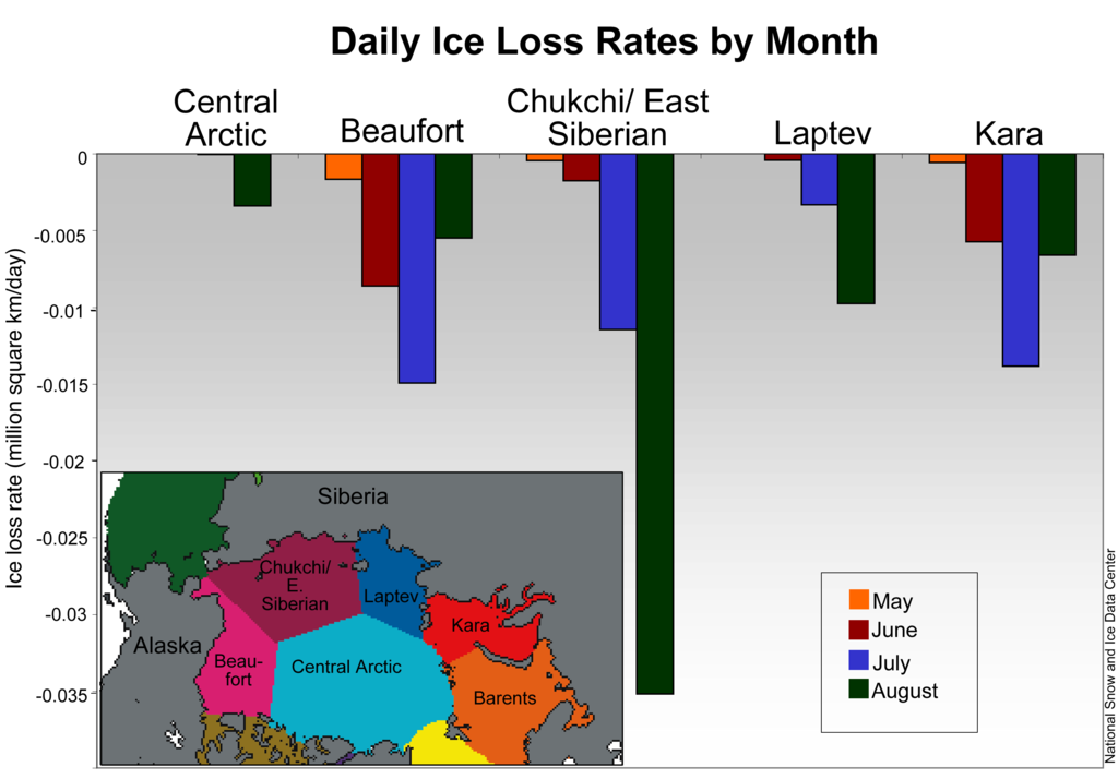
The chart below shows sea ice melt rates by month and sea in 2008.
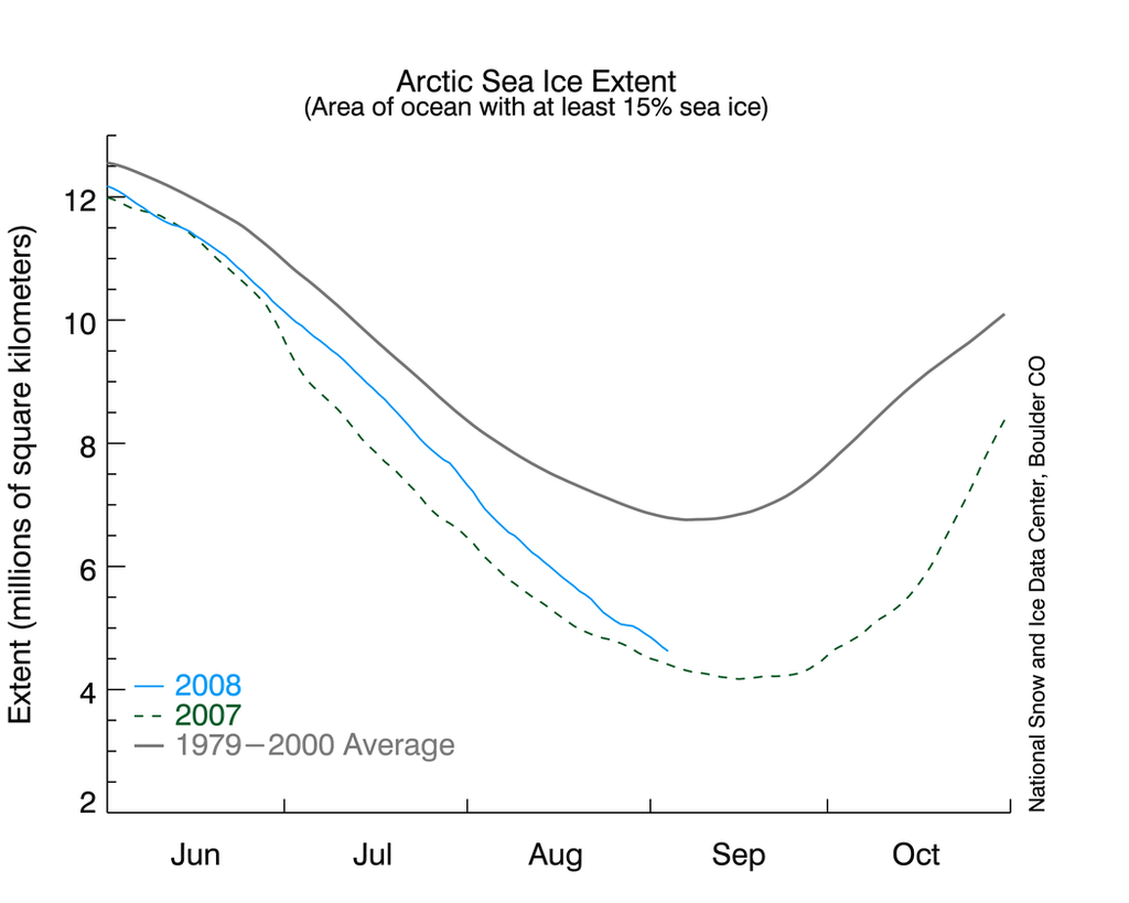
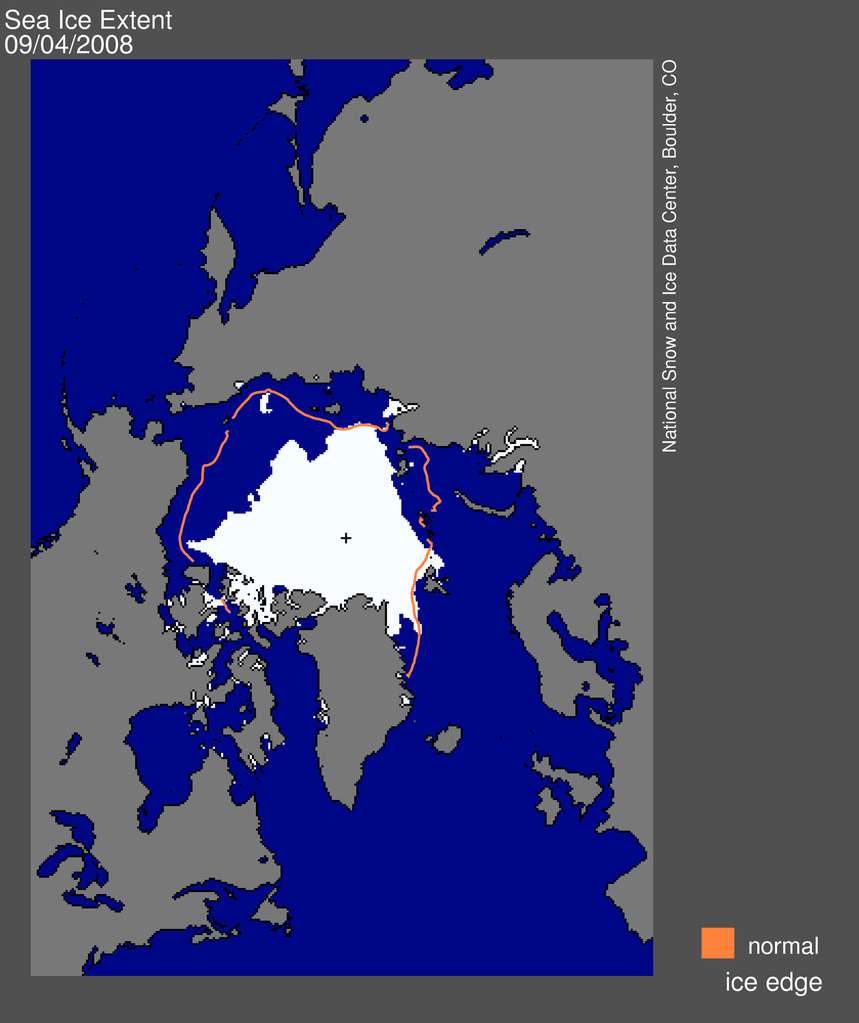
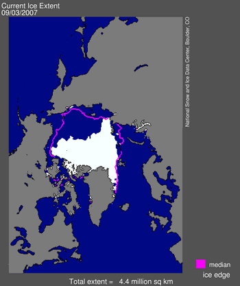
Sea ice extent on September 4, 2008 compared with…
Sea ice extent on September 4, 2007, the current record year.
MSNBC has reported on the collapse of the ice shelves:
Derek Mueller, an Arctic ice shelf specialist at Trent University in Ontario, told The Associated Press that the 4,500-year-old Markham Ice Shelf separated in early August and the 19-square-mile shelf is now adrift in the Arctic Ocean.
The peak temperature the team recorded was 67.5 degrees Fahrenheit (19.7 degrees Celsius), far above the average of 46 degrees Fahrenheit.
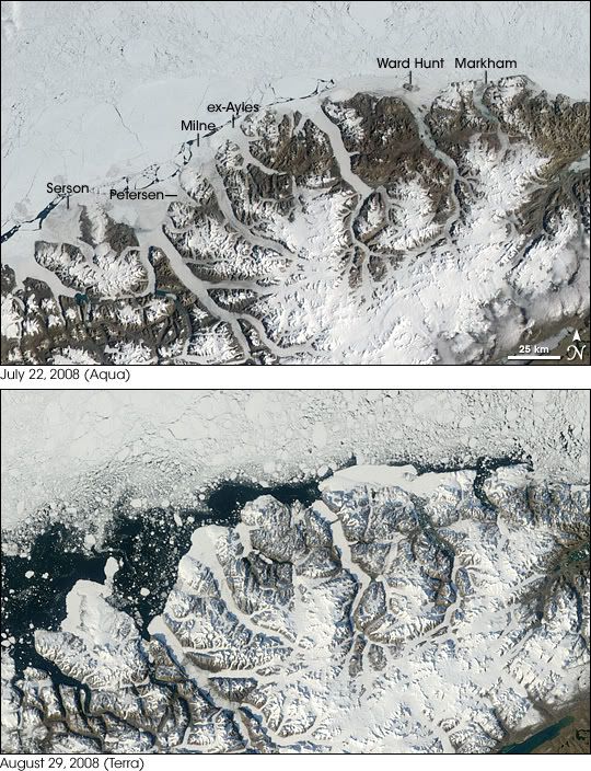
This NASA Earth Observatory image identifies each of the 5 remaining Canadian ice shelves on Ellesmere island and shows their breakup over a 5 week period.
According to Dr. Warwick Vincent of Laval University:
“I think we’re at a point where it is not stoppable but it can be slowed down. And if you think about the magnitude of effects on our society, then we really need to buy ourselves more time to get ready for some very substantial changes that are ahead,” he said.
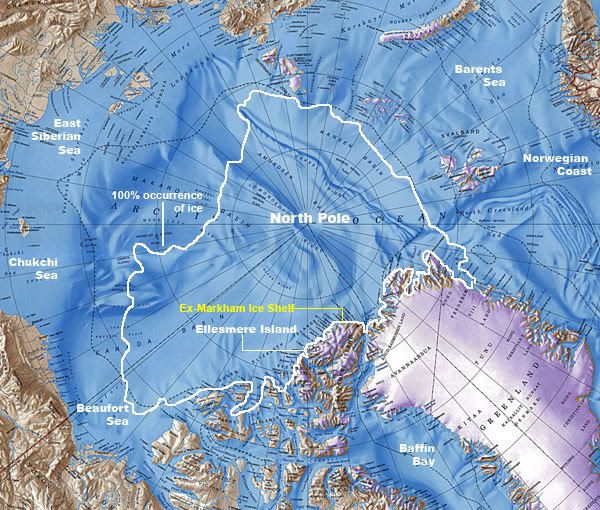
Markham ice sheet overview from Environment Canada
Mueller also said that two large sections of ice detached from the Serson Ice Shelf, shrinking that ice feature by 47 square miles – or 60 percent – and that the Ward Hunt Ice Shelf has also continued to break up, losing an additional eight square miles.
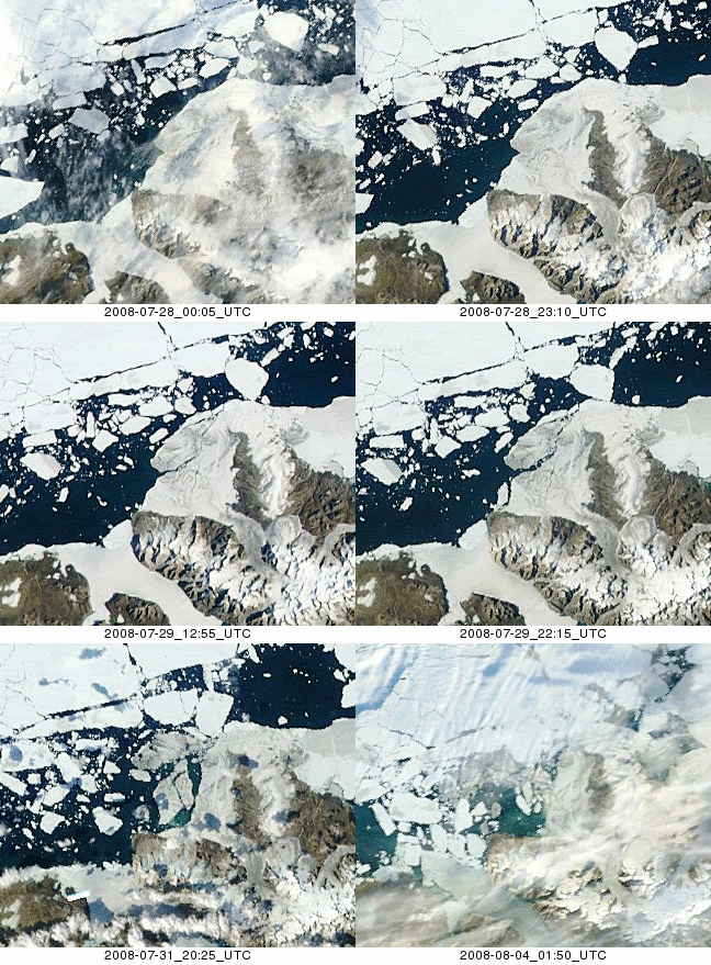
July-August, 2008 MODIS image from the Rapid Response Project at NASA/GSFC. Animation courtesy Derek Mueller, Trent University.
This comes on the heels of unusual cracks in a northern Greenland glacier, rapid melting of a southern Greenland glacier, and a near record loss for Arctic sea ice this summer.
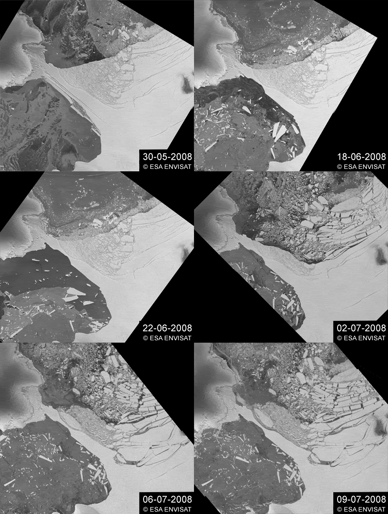
And earlier this year a 160-square mile chunk of an Antarctic ice shelf disintegrated.
Wilkins ice sheet collapsing. Courtesy of European Space Agency.
The CBC also reported on the ice shelves’ collapse:
The ice shelves on the north coast of Ellesmere lost 214 square kilometres over the summer, or an area three times larger than Manhattan Island, said a group of researchers from Ontario, Quebec and the United States on Tuesday.
The entire Markham ice shelf broke away in early August and is now adrift in the Arctic Ocean, carving away 50 square kilometres. Two large sections of the Serson ice shelf also broke off, shrinking it by 122 square kilometres or about 60 per cent. The Ward Hunt ice shelf lost 22 square kilometres.
This means that Quttinirpaaq National Park, Canada’s most northerly, may soon lose its last remaining ice shelf after the loss of its other ice shelf, the Markham, this summer.
Only recently named for a respected Arctic scientist, Harold Serson, the Serson Ice Shelf dammed a 76 km2 freshwater lake measuring approximately four meters deep that sits atop the sea water. The loss of this rare ecosystem is a possibility since it is dependent on the ice shelf staying intact. Dr. Warwick Vincent, Director of Laval University’s Centre for Northern Studies and a researcher in the program ArcticNet, has been studying the ecology of northern Ellesmere Island for more than ten years. He has just returned from his latest expedition to the area, where he observed dramatic changes along the coast. “These ice shelves are formed from the Arctic’s thickest and oldest marine ice” he says, “and the extent of their loss this season is significant. Unique ecosystems that depend on this ice are on the brink of extinction.”
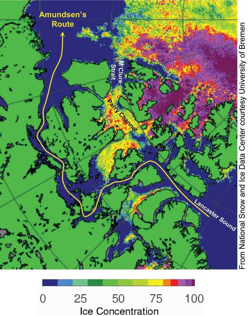
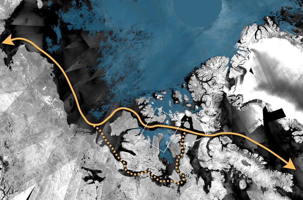
The Northwest Passage is now open in two places:
The above image is from August 8, 2008 when only Amundsen’s Route was open.
Envisat ASAR mosaic from mid-August 2008 showing an almost ice-free Northwest Passage. The direct route through the Northwest Passage is highlighted in the picture by an orange line. The orange dotted line shows the indirect route, called the Amundsen Northwest Passage, which has been passable for almost a month.
Two centuries of fossil fuel consumption have brought us to this: melting ice, species extinction, depleted water supplies, and rising sea levels. For much of humanity, however, it does not seem to have brought any insight. Does anyone besides me find these images from last week’s Republican National Convention terrifyingly reminiscent of the Two Minutes Hate in George Orwell’s 1984? Only now the hatred is directed against the entire planet and everyone who wishes to live sustainably upon it.
Crossposted at Climaticide Chronicles

5 comments
Skip to comment form
PERCENTAGE OF TOTAL POPULATION LIVING IN COASTAL AREAS (PDF)
That’s about 2.7 BILLION people….
My home is about 10m above sea level and about 100m from the beach.
What’s a 10m rise in sea level going to make the Atlantic and Gulf coasts of the U.S. look like? From USGS Sea Level and Climate:
What’s the elevation of your community? Check it out!
Happy to have this on the FP, your work is always welcome here.
The maps are fascinating. And the idea of the Northwest Passage being open, after so much failed effort throughout history to find and exploit it, is ironic to say the least.
This diary is a mine of information, and deeply sobering.
I’m with you on the Republican Convention. Why do Republicans hate the world?