(11 am. – promoted by ek hornbeck)
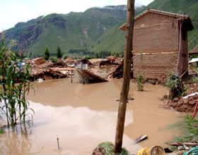
 Devastation in Peru continues. Today’s La Republica reports the bad news:
Intense Rains Leave More than 100,000 Affected
The prolonged rainfall that fell on the southeastern Andes Sunday night left over 100 thousand people affected, with particular intensity in the Cusco region, regional authorities reported.
The regional president of Cusco, Hugo Gonzales, told the AP that on Sunday the rains had left “more than 60 thousand people affected, seven thousand homes destroyed, 17 thousand hectares of crops affected and so far 14 bridges that may collapse from being in poor condition.
Gonzales said that “losses translate into almost $ 250 million dollars and that tourism, the largest employer in the region is losing almost a million dollars a day, which is aggravated by the isolation of Machu Picchu from tourists.
(translation by me)
The report from Puno, to the Southeast, is particularly disturbing:
the rains left “more than 22 thousand farmers affected, 23 million acres of crops worthless, and 25 thousand dead cattle including llamas and vicunas.”
But if you’re not going to read Peruvian newspapers on line, you won’t know much about this disaster. If you’re in the US, just try a Google news search for “Peru floods” and see what it turns up. Right now the top story is from Brunei. And that’s one of the very few entries from today. The rest concern rescuing tourists at the end of last week, some first person tourist stories about being rescued, and the thinnest of reports from Saturday and Sunday.
Long story short, the traditional US media just aren’t reporting about this disaster. And they are apparently not going to. That makes it harder to get contributions and other aid from the US for Peru’s relief. And it also continues the extremely distorted way the US traditional media cover events in this hemisphere.
If we want to end this embargo on news, if we want others in the US to know what’s going on in Peru, the only thing I can think of is writing essays like this one and this one and this one. And if you, dear reader, would consider doing the same, writing an essay, we might be able eventually to overcome the enforced silence and bring US attention to the devastation in Peru. And to other events in this hemisphere.
Finally, I urge readers to make donations to Doctors Without Borders and the Red Cross.
——————
simulposted at The Dream Antilles and daily Kos and Wild Wild Left

8 comments
Skip to comment form
Author
Thanks for reading. And please spread the story around.
Thanks for the updates on Peru! Aid seems to be coming in very minimally — of course, people can only respond to that which they are aware of.
I will make an e-mail of your diaries here and send them to everyone on my list and ask them to try and help and urge them to pass it on.
this is an infrared picture of the pacific ocean, the storms track west towards the east. For scale, if you look up at north america, you can see a smaller one over CA right now (it’s raining lightly here) and 2 others offshore, to the west. But look how much larger the one heading towards South America is.
http://www.goes.noaa.gov/FULLD…
here is the view of South America now, this is another infrared picture as it is now dark. it is relatively quiet now on the pacific coast
http://www.goes.noaa.gov/FULLD…
here is a color enhanced infrared picture of the pacific, looking down towards Australia to the left, one can see these large storms forming far out in the pacific. Looking up into our northern hemisphere, one can see 4 storms- the one that’s over the state of CA right now, the little one just offshore, the one in the middle, and the big honker just off the coast of Japan that is supposed to be a fairly strong one that gets here Thurs. The jet stream has been ALL OVER the place this winter, and long term forecasts are impossible- these storms are going west to east, but wobbling all over the place, and sometimes petering out before they hit us up here.
http://sat.wrh.noaa.gov/satell…
this picture may be animated by clicking “animate” or by clicking here
one great thing about NOAA is that it works on slower connections
http://sat.wrh.noaa.gov/satell…
this is the one to bookmark if you just want to save one, it’s a colorized infrared of both north and south america, and you can click on it to bring up certain areas, or loop it
GOES east interactive Infrared weather satellite image from NASA Global Hydrology and Climate Center
http://wwwghcc.msfc.nasa.gov/G…
We tend to be very insulated and provincial here in the United States, and not realize that the entire planet is one large interactive system of water being heated by the sun out of the oceans, and then airborne and driven by the planet’s rotation pushing the winds, until it falls somewhere else.