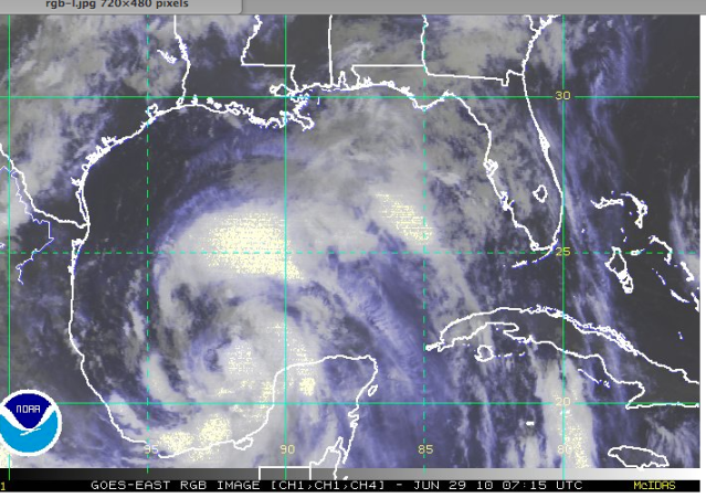
(9AM EST – promoted by Nightprowlkitty)
Update. Tues June 29, 8:20 pm PDT. NWS, Miami, FL. Tropical Storm Alex is now officially a Hurricane, and the first hurricane of the season and the first June hurricane since 1995. Alex is about 255 miles / 415 km SE of Brownsville, TX, with winds of 75 mph, moving 9 mph / 15 km/hr . All watches remain in effect. Hurricane Alex is expected to make landfall late Wednesday evening in the Texas/ Mexico border area.
Status of Deepwater Horizon Oil Rig Area’s “City of Ships” of Blown Out BP Well : Oil skimming operations by surface boats have been suspended. BP Oil is still so far collecting gas/oil from the riser pipe and the BOP, but the attempt to hook up another gathering ship to the BOP to suck up yet more oil from below the sea’s surface has been delayed due to high winds and waves. BP says they are still working on installing yet another floating riser pipe that they can then quickly disconnect from in the case of bad weather, but it’s not finished yet.
Status of relief well. Still close to wellbore, allegedly within 20 feet yesterday, now drilling past it and down and taking multiple magnetic soundings to locate it before attempt is made to intersect. Still supposedly on track for August of this year.
________
Well, I’ve got bad news and good news.
The National Weather Service as of 10:00 pm CDT Monday has upgraded the Hurricane Watch for Tropical Storm Alex to a Hurricane Warning.
But it’s heading northwest to Texas. http://www.nhc.noaa.gov/text/r… Sorry, eastern Mexico, it’s going to visit you again too.
NOAA and the NWS has also put together a page on New Orleans/Baton Rouge/Deepwater Horizon which has every sort of weather graphic you’d want to see on this. Satellite, radar, wind, wave, trajectories, 37 different weather maps and charts to gawk at.
Bookmark this:
http://www.srh.noaa.gov/lix/?n…
Right now according to some reporters with personal weather stations that are monitoring the changes, it’s raining over part of the oil slick towards the Florida panhandle. The winds are from 5 to 20 knots. The winds tomorrow are expected to be southeast, and keep driving the oil back towards the north and west closer to where it’s coming from and back towards the Mississippi delta and to the marshes.
Sample map chart with water currents and storm projectory. You can check off things on the right hand side that you would like to see, then click on the map to add layers to it.
http://nowcoast.noaa.gov/?BOX=…
More satellite picture links from the National Hurricane Center, for all over the world. I like these because they upload easily on a slower connection, and can be animated. http://www.nhc.noaa.gov/satell…
http://www.ssd.noaa.gov/goes/e… The Gulf of Mexico, tonight.
this one is a colorized, animated infrared loop. Look at how this thing is almost splitting, and part of it is tracking more northwards towards Louisiana as of 1 am PDT. Hmm.
(warning. this graphic flashes as it loads, if you are sensitive you may want to look away)
http://www.ssd.noaa.gov/goes/e…
So far we’ve had good luck with this storm track, but I wouldn’t take anything for granted. The winds are projected to be 80 mph later today and 100 mph by the time it makes landfall.


2 comments
Author
…. but you just know that over the next 24 hours, we might just have to work on that a bit harder.
Author