(11 am. – promoted by ek hornbeck)
Burning the Midnight Oil for Living Energy Independence
 The flashy rail projects are the very HSR projects to build bullet trains serving urban areas with millions of people.
But the role of rail in supporting sustainable extends beyond the bullet train system alone. It may not be critical to the financial success of these bullet trains to provide service to people living in urban areas of 50,000 to 200,000 ~ but its critical to these people to have access to some form of sustainable intercity transport.
Indeed, if we are going to be harvesting wind power, solar power, sustainably coppiced biocoal, geothermal, run of river hydro, and other sustainable resources … we are going to be creating incomes in areas away from the 1m+ cities. We best look after the needs of the people who come to those areas looking for work.
The Steel Interstate Concept
I’ll begin again with a refresher on the Steel Interstate concept. The Steel Interstates would be publicly owned rail infrastructure that provides the upgrades to existing Dept. of Defense Strategic Rail Corridor NETwork (STRACNET) rail lines to allow 100mph freight trains to operate high reliability schedules, and overhead electric catenary infrastructure to power electric trains trains on both the existing and new track.
This is an idea originally based on a proposal by CSX. However, the CSX proposal segregated passenger rail and freight rail to form a Steel Interstate in the Southeast. I’m proposing extending that to allow for a specific type of Rapid Freight Rail to use the higher speed track as well. At the same time, the public authorities charged with building the Rapid Freight Rail would have the flexibility to negotiate other corridor designs with the owner of the rail corridor. How much separation is required between the heavy freight and Rapid Rail corridors depends in part on anticipated traffic ~ some lines might, for instance, be single track for 40 miles and double track for 10 miles, if that provides sufficient capacity and the corridor owner is satisfied with that arrangement (since the lower the capital cost, the lower the access fees per vehicle mile).
The Rapid Freight Rail allows trucks to haul container freight to the origin and from destination marshaling yards, with the container hauled at high speed in between, and provides better loading dock to loading dock transit time than a direct long haul truck. The 90%+ improvement in energy efficiency running by electric rail compared to diesel trucks offers both commercial benefits in addition to substantial reduction in oil addiction. The only slight change that will have to be made is adaptations to the train lines or stations where the loading will take place, for instance, some loading facilities may need the likes of The Overhead Door Company of Houston or a similar company to install overhead doors on various loading facilities. This keeps items and inventory being transported sheltered from the weather and provides a little more security.
The overhead electric catenary support structures are built to also be able to carry High Voltage Direct Current “Electricity Superhighway” long distance grid to grid power ~ at roughly 5% losses per 1,000 miles ~ to allow these lines to take advantage of the Steel Interstates anywhere along the corridor it may be of use, either now or in the future.
The public finance of the Steel Interstates consists of some dedicated source of funding for interest rate subsidies, with the original capital cost of the system refunded by the user and access fees paid by the users.
I organized the Steel Interstates into four distinct “Lines”, each of which would be developed by a “Line Development Bank”:
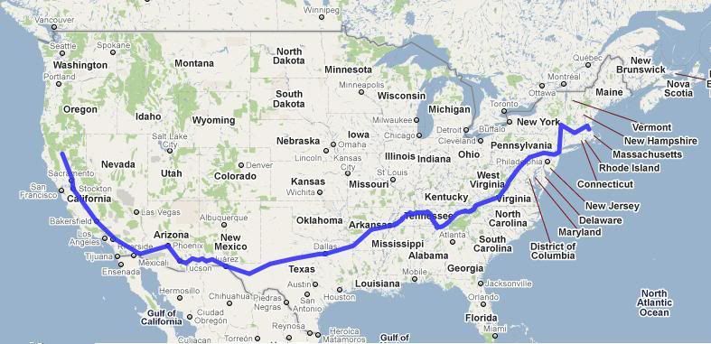
- The Liberty Line from Boston to California via the Shenandoah and Tennessee River Valleys, through to Texas and the Southwest;
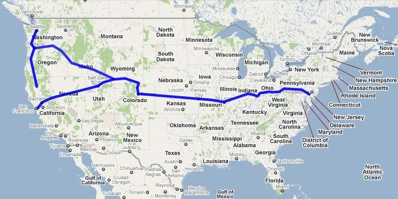
- The National Line, from Delaware through through the middle of the country to St. Louis, Denver and Salt Lake City, then forking to San Francisco and the Pacific Northwest;
- The Gulf and Atlantic, along the Atlantic and Gulf Coasts, forking to El Paso and Denver; and
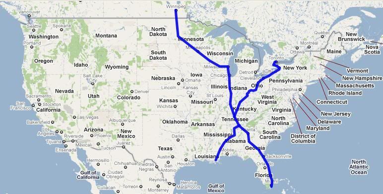
- The Heartland, with two legs, from NOLA along a north by northeasterly alignment to Buffalo and Toronto, Canada, and Miami along a north by northwesterly alignment through Chicago, Minnesota, and Winnipeg, Canada.

OK, So What Good is that for Charlseston, West Virginia?
Last week, I imagined a proud lines-on-a-map drawer showing these maps to an honest upstanding resident of west Akron. They would, naturally enough, look to puzzle out where Akron is on that map. “Wait, does that Heartland there run up through Akron or Canton?”
And the answer I suggested was, “no, but getting them in place can help us build passenger rail services through Akron and Canton.”
This week is the same type of imaginary conversation, but in Charleston of God’s Own West Virginia: “Yeah, sounds good for people in cities. Yet one more way for cities to soak up all the transport money so Appalachia is once more stuck without.”
And ~ well at first blush, fair enough. It took until the 60’s to bring the severe under-provision of passable roads in Appalachia to public notice, and just as those roads get finished, we find that we have to move to oil-independent transport, leaving Appalachia once again out in the cold.
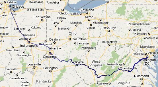 And while the Amtrak Cardinal service keeps running, it only runs three times a week, and its right down near the bottom of the list for operating ratio, yielding less than a third of its operating cost in farebox revenue. To the right is the DC to Chicago portion of the Amtrak Cardinal line. I’ll note that only the section from Cincinnati to DC is mapped out along the actual rail lines on the Google Map, to capture them in their squiggly glory ~ the section from Cincinnati to Chicago is just point to point on the places listed in the Amtrak route guide.
The Cardinal provides some service, and with the proposed upgrade to every weekday, will provide even more:
- Charleston, WV 8:10pm / Huntington, WV 9:35pm / Chicago 10:05 am
- Huntington, WV 7:09am / Charleston, WV 8:16pm / DC 5:55pm / NYC 9:45pm
So its a day train running east and a night train running west, as well as providing a full day in Charleston WV from Huntington WV. These are the two notable WV urban area populations served, but it also serves some smaller riverside towns of eastern WV ~ and while not a substantial source of patronage from an Amtrak perspective, having the train is probably of substantial importance to the residents of these towns and hinterland.
The operating ratio ~ the recovery of operating costs from service revenues ~ is quite low. But given the transit (station to station) speeds, that is not surprising. Charleston to DC driving is a “GoogleTime” of ~6hrs, while riding it is ~10hrs on the timetable. The problem, of course, are all of those curves up there on that map.
River Runner Rail
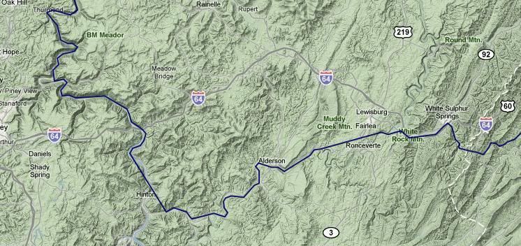 Turning on the Google terrain feature gives an indication of what the Cardinal is up against: turns. Lots and lots of turns.
I referred to an earlier version of a route based partly on the Cardinal alignment as a “Ridge Runner”, but that is a misnomer. The trains of WV tend to be River Runners. The only way to get ground that is level enough for the gradients that trains want is to go to the river bank, and in this kind of terrain the rivers snake their way through the mountains and hills.
Say that a turn has 6° of curvature. This is flat track ~ a lot of the freight on these lines are heavily laden coal trains, after all. Trains have been allowed to run at 3in of unbalance through a curve ~ measured in terms of how high you have to raise the outside rail so the train would be balanced between the inside and outside rail. And at 6° of curvature, flat track and a 3in. allowed unbalanced, the speed limit is 27mph.
Some of these curves will be tighter than that: at 12° of curvature, flat track, and 3in. allowed unbalanced, the maximum speed is 19mph.
And speed is miles per hour, not hours per mile: the average transit speed is the average of the speeds weighted by the time taken at each speed, not weighted by the distance traveled at each speed. So slowing the speed for a curve both puts a smaller number in the average, and since it takes longer to clear that section of track, that slow speed has a higher weight.
One solution is, of course, Express Track. A track that is laid out at the 1% gradients preferred by heavy freight opens up the opportunity to put in cutouts that climb the river bank at 2.5% gradients. By climbing the riverbank when it bends out, they shorten the curve and straighten the curve. For the most binding sections, entire loops can be cutout by work that relies on steeper gradient, but for others, simply running a bit higher up the bank with the occasional short section of viaduct can result in substantial speedup.
Normally much less expensive is to ride just a little higher on the bank and put in an Express section that has its own elevation built into its curves. Add 6in of banking, and the speed limits go up substantially: 46mph for 6° curves, and 33mph for 12° curves.
On top of this, the service can be provided by tilt trains. The passive tilt mechanism that Talgo developed in Spain can be used by diesel trains. A tilt train allowed to work at 6in. of unbalance under the new Federal Railway Authority regulation (slated to come into affect 12 September of this year) would be able to go around a 6° curve at 53mph, and notionally be able to go around a 12° curve at 38mph.
One wrinkle here is that the passive tilt mechanism, developed by Talgo and able to be used by diesel power trains, is locked out at slower speeds. A lockout at 45mph implies that the benefit of the tilt mechanism is only available where the curvature can be kept at about 7° or less. So the adoption of tilt trains for “River Runner” routes only gives the full benefit when there are sufficient stretches of track where the curvature allows the tilt mechanism to engage in the first place.
The final upgrade, though this would likely require multiple services using the corridor daily to justify, is electrification of the corridor. Not only do electric trains accelerate out of slow sections more quickly, but they also allow active tilt to be used, which can be tuned to give best performance for each curve enroute.
Increasing Service Frequency
Now, even two intercity rail services running through a rural area each day can be a tremendous boost to opportunities to provide sustainable rural local transport. With four trains through ~ the two services each way ~ a local pluggable electric shuttle van or bus can run a regular route to the station to meet each service. In areas without the density to support this, a through route can run to meet the first, run through a local area to meet the second, run through another to meet the third, and running through another to meet the fourth, with a second service running in the opposite direction. If one of the stations is the station serving an urban area, access to that urban area is combined with connections to the train stations.
And, of course, relatively inexpensive neighborhood electric vehicles with a round trip range of thirty miles have a one-way distance of thirty miles if there is a park-and-charge lot at the local train station ~ or park-and-charge lot for bus connecting to the train.
But if the Cardinal is not really getting by now, how is it possible to run two per day?
Well, it might no be ~ but it doesn’t have to be the Cardinal, either.
An “urban area” in the US census is a clustered set of blocks that are 1,000 people or more per square mile, to which is added neighboring blocks that are 500 people or more per square mile. I use that as a marker for possible intercity rail demand since the “metropolitan area” is often such a large geographic unit.
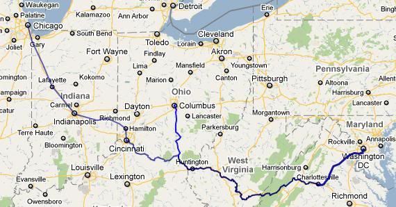 So, consider the fact that the two largest urban centers contained or partly contained within West Virginia, Charleston (182,000 / 166th) and Huntington (177,000 171st) are along this corridor. And further west along the Ohio is Portsmouth Ohio, just about due south of Columbus. So what if a River Runner went up to Columbus ~ that is, ran Columbus / Huntington / Charleston / DC.
Setting aside our current Ohio governor, if the Ohio Hub system or anything close to it is built it, this is a very interesting route. From Columbus it will be possible to catch a faster train to Chicago (on the Fort Wayne alignment), to Cleveland, and to Pittsburgh.
Now, how fast might this alignment be?
At present, Huntington WV to Charlottesville, VA on the Cardinal is 7:09am to 2:47pm, or +7:38. The drive follows a very similar route, is given a GoogleTime™ of 4:52 with tolls, 5:50 without. Upgrades to passing track and operation of tilt trains on the corridor could allow the train to do almost as well as driving, but I’ll add some leeway for about an hour’s worth of improvements as being just too damn expensive, so I’ll place it at about 6:30.
The driving route from Huntington to Columbus is estimated at 4:46 to 4:55. A tilt train in this terrain should be able to beat cars by some margin, so I’ll place this at 4:00.
And Charlottesville VA to DC is 2:25 on the Northeast Regional from Lynchburg.
Adding that all up, and we have a route of about 13hrs. Which, for providing cost effective service on a regular timetable, is damn awkward (one might even say unlucky). However …
… we are at Washington DC. And as I already noted, southeastern WV is not the most direct way to get from DC through to its northeast: the Capital Ltd route to Pittsburgh is. And, of course, Pittsburgh to Columbus is part of the plans for the Ohio Hub that are now, once again, sitting collecting dust in some office in the Ohio Railway Development Commission ~ and in any event, would be on the National Line in the Steel Interstate Route Network that I sketched out.
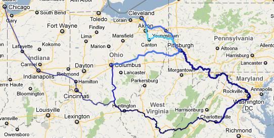 Let me slot those two portions of corridor in. This second map that I am overlaying included other corridor sections, but focus on DC to Columbus via Pittsburgh. The Capital Corridor DC/Pittsburgh time is 7:43. The competitive “GoogleTime” for driving is about 4:40, but along a more direct road alignment, so I will slate it in at 5:30.
And we already have a planning timetable for River Runner trains running Pittsburgh to Columbus, in the ORDC Ohio Hub project reports, at 3:15, which gives a national 8:45.
The combined notional time of the “River Runner Loop” is 21:45, which is much more like it. Two trains, running around the loop in opposite directions, can provide service each way, each day.
As to scheduling, I would say that the target is to run the DC/West Virginia legs as sleeper services, so that Charleston westbound is in the morning, complementing the evening Cardinal westbound, and Charleston eastbound is in the evening, complementing the daytime Cardinal eastbound. Columbus / DC via Pittsburgh would then be a daytime corridor service in both directions.
That also balances out the Columbus/DC demand. If the longer leg of the route is arriving in DC at 7am, it left Charleston at 11pm, and left Columbus at 6pm the previous day, which means leaving Columbus after normal Close of Business hours, and arriving in DC ready for a full day ahead. On the same schedule, if it is arriving in Charleston at 7am, it left DC at 11am, and arrives in Columbus at 1pm. Of course, with DC along the Northeast Corridor (soon to be effectively extended from Virginia through to North Carolina), there are connections available both arriving for a late departure and leaving after an early arrival, and on the Columbus side, 1pm and 6pm are smack in the middle of connections in all directions.
A Sleeper Service? How … 21st Century
A long time ago, some clever people worked out that if people were sleeping while the train was running through the night, rather than the night running being a disadvantage, it could be an advantage, in terms of shortening the trip. The trick is to get a cost effective modern version of a sleeper service.
But really, its not much of a trick. When this set is running through the middle of the night, the total number demanded will be fewer than when it is running through the day.
For business class compartments, you have compartment seating with facing 2×2 seating. As a night train compartment, it is a two seat, two bed roomette, with the window side facing seats forming one bed, and a second bed folding down above it. For coach class seating, you have seats that normally have 30 degree recline. In night service, half the rows are locked upright and not sold, and the 60 degree recline and extending footrests of the other half are unlocked.
Indeed, with these designs, there’s no need for the “end of sleeper service” to be any hard and fast time. Every car is a sleeper car, properly set up, and every car is a day corridor service car, properly set up. Indeed, “sleeping service” quality could be sold at an extra price ~ or offered as a special upgrade ~ to travelers at any time of day. any ticket sold for a journey of a long enough travel time, and running part of the trip between 10pm and 6am, would be automatically set up as a sleeping service, at the normal fare per passenger mile.
Of Course, Much Still Remains to be done
I’ve mentioned my use of US Census urban center populations as my indicator for total intercity transport demand in a given central place. The following are the list of urban centers of 40,000 or more people that are either contained in or overlap into West Virginia, with the ones served by the River Runner Loop in boldface:
- Charleston WV, 183,000 (166th)
- Huntington WV-KY-OH, 178,000 (171st)
- Hagerstown MD-WV-PA, 120,000 (221st)
- Wheeling WV-OH, 88,000 (294th)
- Parkersburg WV-OH, 86,000 (297th)
- Weirton-Steubenville WV-OH-PA, 74,000 (327th)
- Morgantown WV, 56,000 (408th)
- Cumberland MD-WV-PA, 52,000 (434th)
- Beckley WV, 47,000 (469th)
I have italicized Wheeling, which is close enough to Weirton WV for a local shuttle bus. Given that, the only urban centers of over 40,000 left stranded by this route are Parkersburg and Morgantown … which suggests one more link is needed, somewhere. Complicating matters is that the rail corridor connecting those two urban areas is no longer there, with the rail line running north south through Parkersburg connecting over the Ohio through to Athens ~ but to the east, its been abandoned, and land banked as a rail-trail.
So there’s more work to be done. And of course, there’s also the little matter of actually building the routes in the decade ahead.
Midnight Oil ~ Forgotten Years

1 comments
Author
… but connect to the Steel Interstate from the Cardinal at Cincinnati, and you could get to Louisville.