(11 am. – promoted by ek hornbeck)
The morning brings welcome news that densely populated neighborhoods of delightful adobe homes with small gardens have been largely saved from the fire, at least as of the early morning hours.
Calling from the field around 1 a.m., reporter Ethan Stewart, standing just below San Roque and Foothill called the area a “ghost town on the State Street side.” The fire was making a run down San Roque toward downtown.
The fire is only a few hundred yards from Foothill in the San Roque area, but doesn’t appear to be burning any houses at the moment thanks to the firefighters concerted effort to hold Foothill Road.
[snip]An hour later, Stewart said that all things considered it seemed somewhat quiet thanks to firefighters’ heroic efforts. The fire is still being held off Foothill Road.
This is referring to an area where the houses are much more densely packed–charming adobes with small yards packed into neighborhoods leading right into the downtown area. Working 24-hour shifts, the firefighters seem to have averted a catastrophe in the night. A heavy helicopter presence was also reported in the swirling winds and blinding smoke.
Look at this disconcerting bit of information:
WINDS PUSHING THE FIRE TO THE EAST, WHILE WESTERN FLANK IS MOVING WESTWARD
.
Don’t miss this incredible photo of the blood-red moon over Santa Barbara last night. It’s from twitter.
I have this photo on my computer to keep them in my thoughts. Here’s what AvoMonster commented on dkos
I can’t sleep when we have this happening anywhere in So. Cal. I’m very nervous. No offense to those in SB who may not want to be considered part of So. Cal. but it’s close enough, especially when it concerns fire. It’s this time of night when the really bad ones around here have started. Right now in N. SD county there is no wind, temps are lowering from 90 today to maybe 83 tomorrow. But, there is still a red flag warning potential, wind, temps, low humidity, just like October, the fire month. All we lack is the wind.
All it takes is one idiot with an illegal campfire, a signal flare, a stray match or spark from a power tool, brush cutter, tossed cigarette or a fallen power line. Then the conflagration begins.
Yes, he is right, it feels like October, a bad feeling.
You should feel the heat of a brush fire. It’s big big heat. Not like a campfire, bonfire or anything like that. It’s all around heat. The protective clothing helps but all it does is let you get closer to the flames and heat. And, the smoke. In your eyes, throat, lungs, all over. All the while lugging 1-1/2″ hoses that refuse to cooperate, pushing against you with the force of the stream, refusing to move when you need to. Like dragging a wet rolled-up carpet around, they weigh a ton.
We burned a lot of brush here years ago to make our defensible space. I have the scars to prove it, and that was just a controlled and small scale effort. Just a few acres with only 40′ flame columns, no wind, no 100 degree heat. These firefighters are dealing with a monstrous situation. I’m nervous for them, it’s extremely dangerous what is happening right now.
The evacuation area has been expanded, both toward downtown Santa Barbara and the other direction farther out toward the opposite edge of Goleta:
An Evacuation Order has been issued for the area west of the existing evacuation area to include all areas north of US Highway 101 and east of Patterson Avenue.
An Evacuation Warning/Advisory remains in effect for area north of US Highway 101 between Patterson Avenue and Fairview Avenue continuing north from the end of Fairview Avenue to West Camino Cielo (northern boundary). Residents are encouraged to prepare for the need to evacuate in the near future.
Mandatory Evacuation OrdersThe Mandatory Evacuation Order is expanded to include westbound State Street from Constance to La Cumbre, north on La Cumbre to La Colina Road, west on La Colina Road to HWY 154, HWY 154 south to US 101, west on US 101 to Patterson, north on Patterson to San Jose Creek to Camino Cielo. All points north of US 101 boundary are under Mandatory Evacuation Order. All other previous Mandatory Evacuation Order Areas remain in effect.
Evacuation Warnings
The Evacuation Warning Area is expanded to include Alamar at De La Vina, west on Alamar to Junipero St, wets on Junipero St to US 101, north on US 101 to upper State Street, east on State Street to De La Vina south to Alamar Street. Warnings also continue from State Street and De La Vina, De La Vina to Anapamu, Anapamu to Anacapa, Anacapa south to De La Guerra, De La Guerra to Milpas, Milpas south to Quinientos Street, Quinientos Street to Clifton Street to Eucalyptus Hill Road, Eucalyptus Hill Road to Barker Pass, Barker Pass to HWY 192 (Sycamore Canyon Road), HWY 192 (Sycamore Canyon Road) west to Stanwood Drive.
The warning area discussed in the second announcement consists of some mixed residential and business at the edge of the downtown area. The entire evacuation area is potentially huge if those evacuation warnings turn into evacuations. Here’s the map.
This map gives a feel for how much of the city is under evacuation orders or warnings:
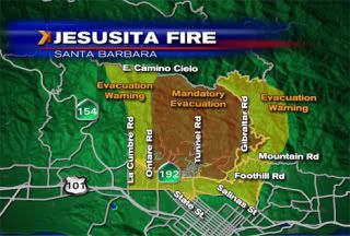
The situation seems quite unstable. Note this announcement:
Jesusita Fire County Call Center Closed
Due to the above Mandatory Evacuation Order, the County Call Center has shut down to relocate overnight. Calls made to (805) 681-5197 will no longer be answered. A new telephone numbers will be distributed for the Call Center when it reopens in the morning in a future press release.
Here’s the fire status as of 5:38 am, according to the Santa Barbara County :
Fire Status
• 2,739 acres burned
• 10% contained
• Damage assessment in progress
initial estimate of 75 homes damaged or destroyed
• 4,715 homes evacuated (mandatory evacuation orders);
affects approx. 12,000 people
• 5,200 homes under evacuation warning;
approx. 12,000 people affected
• Residences threatened – 3500;
commercial properties threatened – 100
• 2,303 personnel on scene: 246 Engines, 62 crews
• 10 fixed wing aircraft and 15 helicopters
• 11 firefighter injuries
• Cause under investigation: Tip line – 805-686-5074
• Air quality warning remains in effect
• Estimated costs to date $1.8 million
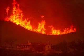
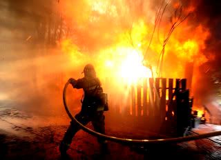
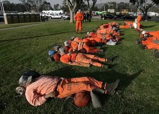
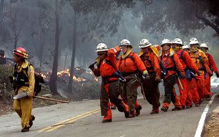
These photos are from yesterday.
I’m sure every one of these firefighters has been on their feet since this was taken sometime yesterday.
Add to the exhaustion this photo shows several more hours of desperate nighttime fighting in hot, smoky, ashy conditions.
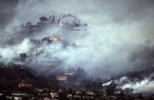
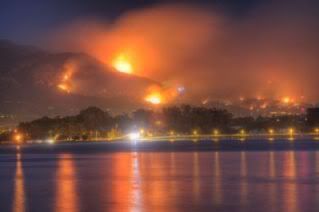
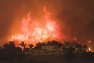
Here are photos from today:
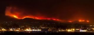
If you don’t know Santa Barbara, that last photo shows an extensive line of fire along the foothills above town. This situation can become a worse catastrophe with one small shift in the wind. It’s very unstable.
It has been very hard to get clear and up-to-date information on this fire. I take that as a measure of how desperately people in Santa Barbara are working to keep up with this. The 11 pm television news last night gave directly contradictory information back to back. After the newsroom reporters said the eastern flank (Montecito) had died down while the western flank was blowing, they went to the field reporter who said the exact opposite.

57 comments
Skip to comment form
Author
Not sleeping well.
Apparently from yesterday.
From VC Star:
Finally, one of the big birds will go into play.
Author
(horrible paper)
People clapping for the firefighters. Old folks in the road. Animals being evacuated, crews working on fire breaks, firemen facing down burning structures.
· 3,500 acres burned
· 10% contained
· Damage assessment in progress – initial estimate of 75 homes have been damaged or
destroyed
· Approximately 12,204 properties evacuated (mandatory evacuation orders); affects
approx. 30,500 people
· More than 9,188 properties under evacuation warning; approx. 23,000 people affected
· Residences threatened – 3500; commercial properties threatened – 100
· 2,335 personnel on scene: 246 engines, 62 crews
· 14 air tankers and 15 helicopters
· 11 firefighter injuries to date
· Cause under investigation: Tip line – 805-686-5074
· Air quality warning remains in effect
· Estimated costs to date $2.6 million
Author
tegrat, who is in Santa Barbara, showed me this good map.
Thank you,
I`m just down the coast in Malibu, & live the same rides you do.
Thank the fates, there was no direct loss of life.
Good luck & let`s keep hoping for that onshore breeze.
Sleep well.