
Author's posts
Jul 09 2012
Le Tour de France 2012: Stage 8
The Tour de France 2012, the world’s premier cycling event kicked off last Saturday with the Prologue in Liège, Belgium and will conclude on July 22 with the traditional ride into Paris and laps up and down the Champs-Élysées. Over the next 22 days the race will take its course briefly along the Northwestern coast of France through Boulogne-sur-Mer, Abbeville and into Rouen then into the mountains of the Jura, Swiss Alps and the Pyrenees.
We will be Live Blogging Le Tour 2012 every morning at The Stars Hollow Gazette starting at 7:30 AM EDT. Come join us for a morning chat, cheer the riders and watch some of the most beautiful and historic countryside in Europe.
Stage 8 went into the mountains of the Jura, starting in the French village of Belfort over seven mountains, the last, the Col de la Croix, a category 1 with an 800 meter 17% climb at the top. From the summit. it was a downhill race to the finish in Porrentruy, the Jurassic Park of Switzerland.
• Stage town on 29 previous occasions
• 51,500 inhabitants
• Head of the Territoire de Belfort
The renowned Lion of Belfort, sculpted by Bartholdi, has seen many champions pass by in the long history of the city, which was the next stage after Metz on the Tour’s route in 1907. A very regular stage of the Tour in the years before the war, the city has often served more often as a stage start than a finish, although Marc Demeyer, the official trailblazer of Freddy Maertens, seized the opportunity in turn to excel there, in 1978. The next day, Bernard Hinault, won the time-trial which allowed him to oust Zoetemelk from the top of the general classification and to wear the Yellow Jersey on the Tour de France for the first time.
Belfort is a city in north-east France in the Franche-Comté région, situated between Lyon and Strasbourg. The residents of the city are called ”Belfortains”. It is located on the Savoureuse, on the strategically important natural route between the Rhine and the Rhône – the Belfort Gap (Trouée de Belfort) or Burgundian Gate (Porte de Bourgogne).
 Belfort is the home of the Lion of Belfort, a sculpture by Frédéric Bartholdi expressing people’s resistance against the siege in the Franco-Prussian War (1870) – who shortly afterwards built the Statue of Liberty in New York.
Belfort’s strategic location, in a natural gap between the Vosges and the Jura, on a route linking the Rhine and the Rhône, has attracted human settlement and made it a target for armies.
The site of Belfort was inhabited in Gallo-Roman times and was subsequently recorded in the 13th century as a possession of the counts of Montbéliard, who granted it a charter in 1307.
Previously an Austrian possession, Belfort was transferred to France by the Treaty of Westphalia (1648), that ended the Thirty Years’ War. The town’s fortifications were extended and developed by the military architect Vauban for Louis XIV.
Until 1871, Belfort was part of the département of Haut-Rhin, in Alsace. The Siege of Belfort, between 3 November 1870 and 18 February 1871, was successfully resisted until the garrison was ordered to surrender 21 days after the armistice between France and Prussia. Because this part of Alsace was French speaking, while the rest of Alsace was German speaking, the area around Belfort was not annexed by the Prussians. It formed, as it still does, the Territoire de Belfort. The siege is commemorated by a huge statue, the Lion of Belfort, by Frédéric Bartholdi.
The town was bombarded by the German army during World War I and occupied by it during World War II. In November 1944 the retreating German army held the French First Army before the town until French Commandos made a successful night attack on the Salbert Fort. Belfort was liberated on 22 November 1944.
• Stage town for the first time
• 6,700 inhabitants
• Cantonal commune of Jura (Switzerland)
The Franco-Swiss stages sometimes carry a lot of weight in the race’s scenario when the Tour goes there. This was the case for example, in 2009 in Verbier, when Alberto Contador dealt a decisive blow to his rivals; or going back a bit further to Crans-Montana, the resort where Laurent Fignon maintained his advantage over Bernard Hinault in 1984. As it so happened, several weeks earlier, the title holder had won a stage in Porrentruy, where the Tour de Romandie goes regularly. More recently a prologue won by Italy’s Marco Pinotti was organised there in 2010, whereas the finish of the last straight stage in 2006 favoured America’s Chris Horner.
Porrentruy is a Swiss municipality and seat of the district of the same name located in the canton of Jura.
 The first trace of human presence in Porrentruy is a mesolithic tool that was found in the back yard of the Hôtel-Dieu. Scattered, individual objects have also been found from the neolithic, the late Bronze Age and the Iron Age. The first known settlement in what became Porrentruy goes back to the Roman era. In 1983, the ruins of a Gallo-Roman temple were discovered in the cemetery on the north of town, and Roman coins were found there. Near the town, a kilometer long (0.6 mile) section of the Augst-Epomanduodurum (now Mandeure) Roman road was discovered.
In the back yard of the Hôtel-Dieu the charred remains of a building from the 10th or 11th century were discovered. However, the first historical mention of the name occurs in 1136 as Purrentru. The name presumably comes from the Latin pons Ragentrudis (Ragentrud bridge). Ragentrud was the wife of the Frankish King Dagobert I. The German form of the name, Pruntrut may have a separate etymology from Bruntrutum, which means an abundant spring.
The first settlement was established in 1140 in the vicinity of Church of Saint-Germain, which was built in the Early Middle Ages. The Counts of Pfirt, who owned the region around Porrentruy, built a castle on a defensible hill and made it the capital of the Ajoie territory. A settlement (now known as the Faubourg de France) was founded at the foot of the castle, with another south on the opposite hill. The city wall was probably built before 1283 and surrounded the two settlements, but not the parish church of Saint-Germain.
In 1236 the Counts of Pfirt pledged the town to the Counts of Montbeliard, however, they retained their rights to the Ajoie until 1281 when they sold the territory to the Bishop of Basel. The Counts of Montbéliard refused to hand over Porrentruy, which led Bishop Henry of Isny to request support from King Rudolph I of Habsburg. After six weeks under siege, the Count relented and handed it over to the Bishop. On 20 April 1283, the The king asked the Bishop of Basel to grant Porrentruy a town charter and make it a free Imperial city. While the Counts of Montbéliard retained some power in the town, their influence waned during the 13th century. [..]
The first parish church of Saint-Germain was replaced in the 13th century by a new building, which underwent several renovations. The Church of Saint-Pierre was completed in 1349 and became the parish church in 1475. The cathedral chapter was established in 1377. Several religious orders were active in the city, including the Jesuits who built their college in 1591. In addition to the Jesuits other orders included the Ursulines (1619), the Sisters of the Annonciade (permanently established in 1646) and the Capuchins (1663).
The first uprising against the Bishop’s power was under the Comité de la Commune de Porrentruy on 20 August 1790, but they were unable to expel the Bishop. However, on 27 April 1792, French Revolutionary troops invaded the city and drove the Bishop out. Porrentruy became the capital of a dependent republic, which was then incorporated into France in 1793 as the Département du Mont Terrible. In 1800, this department was incorporated into the Département du Haut-Rhin as a sub-département. During the War of the Sixth Coalition against Napoleon, Allied troops entered Porrentruy on 24 December 1813. Following their liberation, the future of this former episcopal seat was uncertain. The government divided into two parties, the Episcopal party that sought the return of the prince bishop as the head of a Swiss canton, while the French party wanted to retain the current secular government. However, soon after the fall of Napoleon, the municipality was given to the Canton of Bern (in 1815) to compensate for the loss of the Canton of Vaud, which had become a separate canton in 1803.
Both factions, the religious and the secular, retained power in the town in the following years. The political life in 19th century was characterized by the severe conflict between Liberal-Radicals and the Catholic Conservatives. The secular side gained power in 1860, when the mayor, Joseph Trouillat, was forced out of office. The Radicals retained the mayor’s office and a majority of the town council from 1860 until 1972.
Click on images to enlarge
Jul 08 2012
Today on The Stars Hollow Gazette

Our regular featured content-
- On This Day In History July 8 by TheMomCat
These featured articles-
- Rep. Barney Frank Marries Jim Ready by TheMomCat
our weekly features-
- My Little Town 20120704: Independence Day by Translator
- Six In The Morning: On Sunday by mishima
- Punting the Pundits: Sunday Preview Edition by TheMomCat
- Rant of the Week: Bill Maher by TheMomCat
These Special features-
- 2012 Le Tour – Stage 8 by ek hornbeck
- The British Gran Prix F1 2012: Silverstone by ek hornbeck
Follow us on Twitter @StarsHollowGzt
This is an Open Thread
Jul 08 2012
On This Day In History July 8
Cross posted from The Stars Hollow Gazette
This is your morning Open Thread. Pour your favorite beverage and review the past and comment on the future.
Find the past “On This Day in History” here.
Click on images to enlarge.
July 8 is the 189th day of the year (190th in leap years) in the Gregorian calendar. There are 176 days remaining until the end of the year.
On this day in 1951, Paris celebrates 2,000th birthday. In fact, a few more candles would’ve technically been required on the birthday cake, as the City of Lights was most likely founded around 250 B.C.
The earliest archaeological signs of permanent settlements in the Paris area date from around 4200 BC. The Parisii, a sub-tribe of the Celtic Senones, inhabited the area near the river Seine from around 250 BC. The Romans conquered the Paris basin in 52 BC, with a permanent settlement by the end of the same century on the Left Bank Sainte Geneviève Hill and the Île de la Cité. The Gallo-Roman town was originally called Lutetia, but later Gallicised to Lutèce. It expanded greatly over the following centuries, becoming a prosperous city with a forum, palaces, baths, temples, theatres, and an amphitheatre.
The collapse of the Roman empire and the 5th-century Germanic invasions sent the city into a period of decline. By 400 AD, Lutèce, largely abandoned by its inhabitants, was little more than a garrison town entrenched into a hastily fortified central island. The city reclaimed its original appellation of “Paris” towards the end of the Roman occupation.
The Paris region was under full control of the Germanic Franks by the late 5th century. The Frankish king Clovis the Frank, the first king of the Merovingian dynasty, made the city his capital from 508. The late 8th century Carolingian dynasty displaced the Frankish capital to Aachen; this period coincided with the beginning of Viking invasions that had spread as far as Paris by the early 9th century. Repeated invasions forced Parisians to build a fortress on the Île de la Cité; one of the most remarkable Viking raids was on 28 March 845, when Paris was sacked and held ransom, probably by Ragnar Lodbrok, who left only after receiving a large bounty paid by the crown. The weakness of the late Carolingian kings of France led to the gradual rise in power of the Counts of Paris; Odo, Count of Paris was elected king of France by feudal lords, and the end of the Carolingian empire came in 987, when Hugh Capet, count of Paris, was elected king of France. Paris, under the Capetian kings, became a capital once more.

Jul 08 2012
Open Thread: What We Now Know
Chris Hayes summarizes the news of the week as he talks about the intended tax hikes in France under newly elected President François Hollande. He is joined on the panel by Jared Bernstein (@econjared), MSNBC contributor, former Chief Economist & Economic Policy Advisor to Vice President Joe Biden, Senior Fellow at the Center for Budget and Policy Priorities; Karl Smith (@ModeledBehavior), Assistant Professor of Economics and Government at The University of North Carolina at Chapel Hill and contributor to the Forbes blog Modeled Behavior; Jamila Bey (@jbey), Contributing writer to Washington Post blog She the People, and reporter for Voice of Russia Radio; Annie Lowrey (@AnnieLowrey), economic policy reporter for The New York Times.
Jul 08 2012
Le Tour de France 2012: Stage 7
The Tour de France 2012, the world’s premier cycling event kicked off last Saturday with the Prologue in Liège, Belgium and will conclude on July 22 with the traditional ride into Paris and laps up and down the Champs-Élysées. Over the next 22 days the race will take its course briefly along the Northwestern coast of France through Boulogne-sur-Mer, Abbeville and into Rouen then into the mountains of the Jura, Swiss Alps and the Pyrenees.
We will be Live Blogging Le Tour 2012 every morning at The Stars Hollow Gazette starting at 7:30 AM EDT. Come join us for a morning chat, cheer the riders and watch some of the most beautiful and historic countryside in Europe.
Stage 7 start and finish were two new locales for Le Tour, the village of Tomblaine and a ski station on the last summit of the Vosges, La Planche des Belles Filles. The riders left the plains and began the rigorous part of the race into the mountains. The mountains in this stage are considered “medium” but the last leg to the summit finish is a category 1 mountain with the last 850 meter at a leg muscle screaming incline of 14%.
Today’s stage start and finish are two new locales for Le Tour, the village of Tomblaine and a ski station on the last summit of the Vosges, La Planche des Belles Filles.

Tomblaine
• Stage town for the first time
• 8,000 inhabitants
• Head of the canton of Meurthe-et-Moselle
 A new town on the Tour de France’s map, Tomblaine is situated in the sphere of influence of Nancy, where the peloton has been going since 1905. Fausto Coppi, Louison Bobet and Bernard Hinaul have been winners there, but the memory which is the freshest in our minds is that of Christophe Mengin’s bitter disappointment in the 2005 Tour. The stage’s regional rider had every opportunity to win, by joining the breakaway of the day, and then leaving his fellow riders behind him in the final stretch. The several second’s lead that he still had after the red pennant should have been enough, but he was caught out by the rain and the rider from Lorraine finished his route by crashing into the barriers on the edge of the last bend. Italy’s Lorenzo Bernucci took advantage of his bad luck.
• Stage site for the first time
• The summit of the Vosges massive (1148 m) in Haute-Saône
 The only ski resort in the department of Haute-Saône and the last summit of the Vosges, La Planche des Belles Filles (English: Board of the pretty girls) is going to make a promising entrance among the Tour de France’s finish sites. Although the final slope seems to be reserved for the strongest climbers, this place takes its name from a collective and hopeless flight of the women of the valley, who wanted to escape from a massacre declared by the Vikings during their conquest in the 15 th century. The station’s name, according to legend, dates to 1635 when a Swedish soldier engraved an epitaph to some local girls who drowned whilst fleeing him and his men.
Jul 07 2012
Today on The Stars Hollow Gazette

Our regular featured content-
- On This Day In History July 7 by TheMomCat
- Punting the Pundits by TheMomCat
And these featured articles-
- Popular Culture 20120706: The Hateful American Family Association (With Poll!) by Translator
- Drone “Pilots” Practice on Us by: TheMomCat
- Health and Fitness News by TheMomCat
- Random Japan by mishima
These special features-
- 2012 Le Tour – Stage 7 by ek hornbeck
- The British Grand Prix F1 2012: Silverstone Qualifying by ek hornbeck
Follow us on Twitter @StarsHollowGzt
Write more and often. This is an Open Thread.
Jul 07 2012
Le Tour de France 2012: Stage 6
The Tour de France 2012, the world’s premier cycling event kicked off last Saturday with the Prologue in Liège, Belgium and will conclude on July 22 with the traditional ride into Paris and laps up and down the Champs-Élysées. Over the next 22 days the race will take its course briefly along the Northwestern coast of France through Boulogne-sur-Mer, Abbeville and into Rouen then into the mountains of the Jura, Swiss Alps and the Pyrenees.
We will be Live Blogging Le Tour 2012 every morning at The Stars Hollow Gazette starting at 7:30 AM EDT. Come join us for a morning chat, cheer the riders and watch some of the most beautiful and historic countryside in Europe.
The last time a Tour de France stage started in Épernay, home to the leading Champagne houses, was in 2010 and it was HTC-Columbia that were cracking open the bubbly that evening to celebrate yet another stage win by Mark Cavendish. This is another stage that looks nailed-on for a bunch sprint finish.
Épernay is a commune in the Marne department in northern France, located some 130 km north-east of Paris. The town sits on the left bank of the Marne at the extremity of the Cubry valley which crosses it. Épernay is best known as the principal “entrepôt” for champagne wines, which are bottled and kept in large cellars built into the chalk rock on which the town is built. The production of the equipment and raw materials used in the champagne industry is a major source of local employment.
 The most famous street in Épernay is the Avenue de Champagne which features the leading Champagne manufacturers. Its name derives from the presence of many leading champagne producers such as Moët et Chandon, Mercier and De Castellane. Residents say that this avenue is the most expensive in the world, more so than the Champs-Élysées in Paris, because of the millions of bottles of champagne stored in the kilometres of chalk cellars beneath it.
Épernay is the home of Moët et Chandon which was founded in 1743 by Épernay wine trader Claude Moët who began shipping his wine from Champagne to Paris. The reign of King Louis XV coincided with increased demand for sparkling wine. Moët began business in 1750 with Madame de Pompadour, who supplied the Royal Court at Compiègne with Moët’s champagne. Also in 1750, Moët began establishing business in Germany, Spain, Eastern Europe, and colonial British America. In 1792, on Claude Moët’s death, grandson Jean-Rémy Moët assumed control of Moët et Cie, and expanded the business buying the vineyards of the Abbey of Hautvillers, where Benedictine monk Dom Pérignon perfected double-fermentation for creating champagne.
Metz, the capital of Lorraine, has witnessed 40 stage finishes since it first welcomed the Tour more than a century ago, the most recent being in 1999 when Lance Armstrong won an individual time trial here on his way to the first of his seven consecutive victories in the race. This close to the German border there should be a lot of German fans in evidence, but with Kittel out and Greipel coming in to this stage having already achieved back to back stage wins on stages 4 and 5 it’s unlikely that they will see that ultra rarity – a Tour treble… but you never know, the last one was achieved by Lance Armstrong and included an individual time trial. Super Mario Cipolinni went one better in 1999 winning four in a row with none of the time trials included.
 Metz is a city in the northeast of France located at the confluence of the Moselle and the Seille rivers. Metz is the capital of the Lorraine region and prefecture of the Moselle department. Located near the tripoint along the junction of France, Germany, and Luxembourg, Metz forms a central place of the European Greater Region and of the SaarLorLux Euroregion.
A Celtic oppidum, an important Gallo-Roman city, the Merovingian capital of the Austrasia kingdom, the birthplace of the Carolingian dynasty, a cradle of the Gregorian chant, and one of the oldest republics of the common era in Europe, Metz has a rich 3,000-year-history. The city has been steeped in Romance culture, but has been strongly influenced by Germanic culture due to its location and history.
Metz possesses one of the largest Urban Conservation Area in France and more than 100 buildings of the city are classified on the Monument Historique list. Because of its historical and cultural background, Metz benefits from its designation as French Town of Art and History. The city features noteworthy buildings such as the Gothic Saint-Stephen Cathedral, the Basilica of Saint-Pierre-aux-Nonnains, its Station Palace, or its Opera House, the oldest one working in France. Metz is home to some notable venues including the Arsenal Concert Hall and the Centre Pompidou-Metz Museum.
A basin of urban ecology, Metz gained its nickname of Green City, displaying extensive open grounds and public gardens and the historic downtown is one of the largest commercial, pedestrian areas in France.
A historic Garrison town, Metz is the economic heart of the Lorraine region, being specialized in information technology and automotive industries. Metz is home to the University of Lorraine and a centre for applied research and development in the materials sector notably in metallurgy and metallography, the heritage of the Lorraine region’s past in the iron and steel industry.
Jul 07 2012
Health and Fitness News
 Welcome to the Health and Fitness News, a weekly diary which is cross-posted from The Stars Hollow Gazette. It is open for discussion about health related issues including diet, exercise, health and health care issues, as well as, tips on what you can do when there is a medical emergency. Also an opportunity to share and exchange your favorite healthy recipes.
Questions are encouraged and I will answer to the best of my ability. If I can’t, I will try to steer you in the right direction. Naturally, I cannot give individual medical advice for personal health issues. I can give you information about medical conditions and the current treatments available.
You can now find past Health and Fitness News diaries here and on the right hand side of the Front Page.

The savory bread puddings I’ve always made have been Italian strata, casseroles made with cubes or slices of bread, milk, eggs, cheese and vegetables. I was recently introduced to an Alsatian version of a sweet bread pudding, in which the bread is soaked in the milk first, then beaten with eggs, sugar and flavorings, folded with beaten egg whites, and poured into a baking dish over fruit. I loved this technique, because there were no hard, dry edges of bread after baking, so I applied it to my savory bread puddings too (without separating the eggs), and got delicious results. The puddings are moist, with a bonus layer of custard that seeps out of the bread crumbs at the bottom of the casserole dish. The sweet ones, in which the eggs are separated, puff like soufflés.
You can use baguettes or country bread for these, white or whole-wheat. I tried them with whole-wheat sandwich bread, but the sliced bread didn’t hold the custard as well and the puddings were a bit soggy.
~Martha Rose Shuman~
Half of a stale baguette soaked in milk makes for an incredibly moist dish.
Savory Bread Pudding With Grated Squash and Feta
Dill or mint lends Greek overtones to this comforting dish.
Savory Whole-Wheat Bread Pudding With Seared Tomatoes and Mushrooms
If you’re eager to use the season’s first tomatoes, this is a good vehicle for them, as they can be slightly underripe.
A lighter version of a traditional Alsatian dish called a bettelmann, this sweet dish features a classic pairing: cherries and almonds.
Even apricots that aren’t at the peak of sweetness develop an intense flavor as they bake.
Jul 07 2012
On This Day In History July 7
Cross posted from The Stars Hollow Gazette
This is your morning Open Thread. Pour your favorite beverage and review the past and comment on the future.
Find the past “On This Day in History” here.
Click on images to enlarge.
July 7 is the 188th day of the year (189th in leap years) in the Gregorian calendar. There are 177 days remaining until the end of the year.
The terms 7th July, July 7th, and 7/7 (pronounced “Seven-seven”) have been widely used in the Western media as a shorthand for the 7 July 2005 bombings on London’s transport system. In China, this term is used to denote the Battle of Lugou Bridge started on July 7, 1937, marking the beginning of the Second Sino-Japanese War.
On this day in 1898, U.S. President William McKinley signs the Newlands Resolution annexing Hawaii as a territory of the United States.
In 1898 President of the United States William McKinley signed the treaty of annexation for Hawaii, but it failed in the senate after the 38,000 signatures of the Ku’e Petitions were submitted. After the failure Hawaii was annexed by means of joint resolution called the Newlands Resolution.
The Territory of Hawaii, or Hawaii Territory, was a United States organized incorporated territory that existed from July 7, 1898, until August 21, 1959, when its territory, with the exception of Johnston Atoll, was admitted to the Union as the fiftieth U.S. state, the State of Hawaii.
The U.S. Congress passed the Newlands Resolution which annexed the former Kingdom of Hawaii and later Republic of Hawaii to the United States. Hawaii’s territorial history includes a period from 1941 to 1944 – during World War II – when the islands were placed under martial law. Civilian government was dissolved and a military governor was appointed.
On 7 July 1898, McKinley signed the Newlands Resolution (named after Congressman Francis Newlands) which officially annexed Hawaii to the United States. A formal ceremony was held on the steps of ‘Iolani Palace where the Hawaiian flag was lowered and the American flag raised. Dole was appointed Hawaii’s first territorial governor.
The Newlands Resolution said, “Whereas, the Government of the Republic of Hawaii having, in due form, signified its consent, in the manner provided by its constitution, to cede absolutely and without reserve to the United States of America, all rights of sovereignty of whatsoever kind in and over the Hawaiian Islands and their dependencies, and also to cede and transfer to the United States, the absolute fee and ownership of all public, Government, or Crown lands, public buildings or edifices, ports, harbors, military equipment, and all other public property of every kind and description belonging to the Government of the Hawaiian Islands, together with every right and appurtenance thereunto appertaining: Therefore, Resolved by the Senate and House of Representatives of the United States of America in Congress assembled, That said cession is accepted, ratified, and confirmed, and that the said Hawaiian Islands and their dependencies be, and they are hereby, annexed as a part of the territory of the United States and are subject to the sovereign dominion thereof, and that all and singular the property and rights hereinbefore mentioned are vested in the United States of America.”
The Newlands Resolution established a five-member commission to study which laws were needed in Hawaii. The commission included: Territorial Governor Sanford B. Dole (R-Hawaii Territory), Senators Shelby M. Cullom (R-IL) and John T. Morgan (D-AL), Representative Robert R. Hitt (R-IL) and former Hawaii Chief Justice and later Territorial Governor Walter F. Frear (R-Hawaii Territory). The commission’s final report was submitted to Congress for a debate which lasted over a year. Congress raised objections that establishing an elected territorial government in Hawaii would lead to the admission of a state with a non-white majority.

Jul 06 2012
Today on The Stars Hollow Gazette
Our regular featured content-
- On This Day In History July 6 by TheMomCat
- Punting the Pundits by TheMomCat
These featured articles-
- LIBOR Just Won’t Go Away by TheMomCat
- High Speed Rail Vote In California by TheMomCat
This special feature-
- 2012 Le Tour – Stage 6 by ek hornbeck
Follow us on Twitter @StarsHollowGzt
This is an Open Thread
Jul 06 2012
On This Day In History July 6
Cross posted from The Stars Hollow Gazette
This is your morning Open Thread. Pour your favorite beverage and review the past and comment on the future.
Find the past “On This Day in History” here.
Click on images to enlarge.
July 6 is the 187th day of the year (188th in leap years) in the Gregorian calendar. There are 178 days remaining until the end of the year.
On this day in 1917, Arabian troops led by T. E. Lawrence (“Lawrence of Arabia”) and Auda ibu Tayi capture Aqaba from the Ottoman Empire during the Arab Revolt.
Lawrence, sent by General Archibald Murray, commander of the Egyptian Expeditionary Force, to act as a military advisor to Emir Faisal I, convinced the latter to attack Aqaba. Aqaba was a Turkish-garrisoned port in Jordan, which would threaten British forces operating in Palestine; the Turks had also used it as a base during their 1915 attack on the Suez Canal. It was also suggested by Faisal that the port be taken as a means for the British to supply his Arab forces as they moved further north. Though he did not take part in the attack itself (his cousin Sherif Nasir rode along as the leader of his forces), Faisal lent forty of his men to Lawrence. Lawrence also met with Auda ibu Tayi, leader of the northern Howeitat tribe of Bedouin, who agreed to lend himself and a large number of his men to the expedition. Lawrence informed his British colleagues of the planned expedition, but they apparently did not take him seriously, expecting it to fail.
Aqaba was not in and of itself a major military obstacle; a small village at the time, it was not actually garrisoned by the Turks, though the Turks did keep a small, 400-man garrison at the mouth of the Wadi Itm to protect from landward attack via the Sinai Peninsula. The British Royal Navy occasionally shelled Aqaba, and in late 1916 had briefly landed a party of Marines ashore there, though a lack of harbor or landing beaches made an amphibious assault impractical. The main obstacle to a successful landward attack on the town was the large Nefud Desert, believed by many to be impassable.
The expedition started moving towards Aqaba in May. Despite the heat of the desert, the seasoned Bedouins encountered few obstacles aside from occasional harassment from small bands of Arabs paid off by the Turks; they lost more men to attacks by snakes and scorpions than to enemy action. During the expedition, Auda and Lawrence’s forces also did severe damage to the Hejaz Railway.
Auda and his men reached the Wadi Sirhan region, occupied by the Rualla tribe. Auda paid 6,000 pounds in gold to their leader to allow his men to use Wadi Sirhan as a base.
The actual battle for Aqaba occurred for the most part at a Turkish blockhouse at Abu el Lissal, about halfway between Aqaba and the town of Ma’an. A group of separate Arab rebels, acting in conjunction with the expedition, had seized the blockhouse a few days before, but a Turkish infantry battalion arrived on the scene and recaptured it. The Turks then attacked a small, nearby encampment of Arabs and killed several of them.
After hearing of this, Auda personally led an attack on the Turkish troops there, attacking at mid-day on July 6. The charge was a wild success. Turkish resistance was slight; the Arabs brutally massacred hundreds of Turks as revenge before their leaders could restrain them. In all, three hundred Turks were killed and another 150 taken prisoner, in exchange for the loss of two Arabs killed and a handful of wounded. Lawrence was nearly killed in the action; he accidentally shot the camel he was riding in the head with his pistol, but was fortunately thrown out of harm’s way when he fell. Auda was grazed numerous times, with his favorite pair of field glasses being destroyed, but was otherwise unharmed.
Meanwhile, a small group of British naval vessels appeared offshore of Aqaba itself and began shelling it. At this point, Lawrence, Auda, and Nasir had rallied their troops; their total force had been quadrupled to 2,000 men by a local Bedouin who, with the defeat of the Turks at Lissal, now openly joined Lawrence’s expedition. This force maneuvered themselves past the outer works of Aqaba’s defensive lines, approached the gates of Aqaba, and its garrison surrendered without further struggle.
Jul 05 2012
Le Tour de France 2012: Stage 5
The Tour de France 2012, the world’s premier cycling event kicked off last Saturday with the Prologue in Liège, Belgium and will conclude on July 22 with the traditional ride into Paris and laps up and down the Champs-Élysées. Over the next 22 days the race will take its course briefly along the Northwestern coast of France through Boulogne-sur-Mer, Abbeville and into Rouen then into the mountains of the Jura, Swiss Alps and the Pyrenees.
We will be Live Blogging Le Tour 2012 every morning at The Stars Hollow Gazette starting at 7:30 AM EDT. Come join us for a morning chat, cheer the riders and watch some of the most beautiful and historic countryside in Europe.
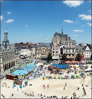
La Plage de l’Hôtel de Ville
Stage 5 began where it ended in Stage 4, Rouen and continued over mostly flat terrain for 196.5 km to Saint-Quentin, a commune in the Aisne department in Picardy in northern France. It is named after Saint Quentin, who is said to have been martyred here in the 3rd century.
The city was founded by the Romans, in the Augustean period, to replace the oppidum of Vermand (11 km away) as the capital of Viromandui (Celtic Belgian people who occupied the region). It received the name of Augusta Viromanduorum, Augusta of the Viromandui, in honor of the Emperor Augustus. The site is that of a ford across the River Somme. During the late Roman period, it is possible that the civitas capital was transferred back to Vermand (whose name comes from Veromandis); almost nothing relating to the 4th century has been found in Saint-Quentin.
During the early Middle Ages, a major monastery developed, based on pilgrimage to the tomb of Quentin, a Roman Christian who came to evangelize the region and was martyred in Augusta, giving rise to a new town which was named after him.
From the 9th century, Saint-Quentin was the capital of Vermandois County. From the 10th century, the counts of Vermandois (descendants of the Carolingian, then Capetian families) were very powerful. The city grew rapidly: the “bourgeois” organized themselves and obtained, in the second half of the 11th century (a very early date), a municipal charter which guaranteed their commune a large degree of autonomy.
At the beginning of the 13th century, Saint-Quentin entered the royal domain. At that time, it was a thriving city, based on its wool textile industry (city “drapante”). It was also a centre of commerce boosted by its position on the border of the kingdom of France, between the Champagne fairs and the cities of Flanders (wine exportation, etc.): it had an important annual fair. It also benefited from its location in the heart of a rich agricultural region (trade of grain and “guède”, woad, a high-value blue colouring pigment). to have been martyred here in the 3rd century. [..]
The First World War hit St Quentin very hard. In September 1914, the city was over-run, and it endured a harsh occupation. From 1916, it lay at the heart of the war zone, because the Germans had integrated it into the Hindenburg Line. After the evacuation of the population in March, the town was systematically looted and industrial equipment removed or destroyed. The fighting destroyed it: 80% of buildings (including the Basilica) were damaged.
Despite national support, the reconstruction process was long, and the city struggled to regain its pre-1914 dynamism. The 1911 population of 55,000 was achieved again only in the mid-1950s, in the context of general economic expansion. This prosperity continued until mid-1970s, when the French textile industry began to suffer through competition from developing countries.