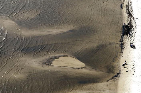
Volunteers cleaning a beach in Louisiana

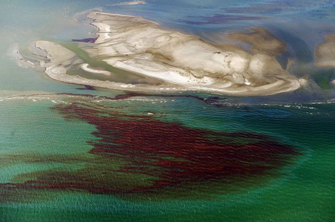
Oil slick approaching Channeleur Islands (Mark Ralston, AFP/Getty Images)

May 13 2010
May 12 2010
 The Gulf of Mexico Foundation‘s website says it was “founded in 1990 by citizens concerned with the health and productivity of the Gulf of Mexico.” Its site shows it has sponsored conservation and educational programs and partnered with the likes of the Environmental Protection Agency and the National Oceanic and Atmospheric Administration. The site also says the group represents a “wide range of interests,” including “agriculture, business, fisheries, industry, tourism, and the environment.”
But as it turns out, industry appears to be the most represented of those interests.
At least half of the 19 members of the group’s board of directors have direct ties to the offshore drilling industry. One of them is currently an executive at Transocean, the company that owns the Deepwater Horizon rig.
The Gulf of Mexico Foundation’s slogan is:
America’s Sea … Keep It Shining
May 11 2010
Ken Salazar’s first pledge as secretary of the interior was to reform the scandal plagued Mineral Management Service (MMS), which had been found by the U.S. inspector general to have traded sex, drugs, and financial favors with oil-company executives. In a January 29, 2009 press release on the scandal, Salazar stated:
“President Obama’s and my goal is to restore the public’s trust, to enact meaningful reform…to uphold the law, and to ensure that all of us — career public servants and political appointees — do our jobs with the highest level of integrity.”
Yet just three months later, Secretary Salazar allowed the MMS to approve – with no environmental review – the BP drilling operation that exploded on April 20, 2010, killing 11 workers and pouring millions of gallons of oil into the Gulf of Mexico. The disaster will soon be, if it is not already, the worst oil spill in American history.
BP submitted its drilling plan to the MMS on March 10, 2009. Rather than subject the plan to a detailed environmental review before approving it as required by the National Environmental Policy Act, the agency declared the plan to be “categorically excluded” from environmental analysis because it posed virtually no chance of harming the environment.
As BP itself pointed out in its April 9, 2010, letter to the Council on Environmental Quality, categorical exclusions are only to be used when a project will have “minimal or nonexistent” environmental impacts.
But how could Obama have known that Ken Salazar is a gung-ho booster of offshore drilling, instead of a responsible guardian of the public interest?
Let’s blame it all on Salazar, and BP, and Halliburton, and… anybody but Obama!
But…
In 2006, while Salazar was in the Colorado Senate, he fought to get increased oil and gas leases in the Gulf Coast region, by sponsoring the Gulf of Mexico Energy Security Act of 2006.
Now some people are calling the Deepwater Horizon catastrophe “Obama’s Katrina,” but that characterization is completely unfair… to George W. Bush.
Because nobody claims that Bush could have prevented Hurricane Katrina, like Obama could have prevented the Deepwater Horizon disaster, by enforcing existing environmental law.
May 11 2010
You can take many of the reports we’ve been given and just imagine what happened when the rig exploded and since. There are always many story lines that can be followed, we can only be witness to what’s shown to us and stated by our media and others.
One of the tragic story lines, and now being finally mentioned in these tragic incidents, is the possibility of Post Traumatic Stress that may start to develop and what might cause the growth of in some of the individuals who survive.
Joseph Shapiro had a series of reports on NPR and tonight a video report and discussion with one of the survivors on the PBS News Hour.
May 10 2010
Last week we discussed the Deepwater Horizon blowout and the resultant huge oil spill, and will continue the discussion tonight. By the way, the title of this piece represents the official NOAA estimate of the release. Some estimates are as much as five to ten times this amount, but the NOAA estimate one is the official one, so we will use it.
It really makes little difference, because even the official estimate is huge. Since this happened on 20100420, with the rig sinking and presumably destroying the riser on 20100422, at the official rate for the 18 days now 3.7 million gallons have been released.
May 09 2010
May 07 2010
Slick Operator: The BP I’ve Known Too Well
Greg Palast
I’ve seen this movie before. In 1989, I was a fraud investigator hired to dig into the cause of the Exxon Valdez disaster. Despite Exxon’s name on that boat, I found the party most to blame for the destruction was … British Petroleum (BP).
That’s important to know, because the way BP caused devastation in Alaska is exactly the way BP is now sliming the entire Gulf Coast.
Tankers run aground, wells blow out, pipes burst. It shouldn’t happen, but it does. And when it does, the name of the game is containment. Both in Alaska, when the Exxon Valdez grounded, and in the Gulf last week, when the Deepwater Horizon platform blew, it was British Petroleum that was charged with carrying out the Oil Spill Response Plans (OSRP), which the company itself drafted and filed with the government.
What’s so insane, when I look over that sickening slick moving toward the Delta, is that containing spilled oil is really quite simple and easy. And from my investigation, BP has figured out a very low-cost way to prepare for this task: BP lies. BP prevaricates, BP fabricates and BP obfuscates.
That’s because responding to a spill may be easy and simple, but not at all cheap. And BP is cheap. Deadly cheap.
May 05 2010
Ia ora te natura
E mea arofa teie ao nei
Its in the coastlines now, in the harbors, bays and myriad brackish branches of the bayou. Visions of fingerling rainbows sparkling their false gold promise in the sun, creep into my view. Beautiful death, such a mask for the evil. Bright orange globs and tarred waters tint and leach into these relentless prismatic wisps, breaking free and meandering, searching, seeking to spread its chokehold throughout the very alveoli that breathes life into the Gulf.

Mother, mother ocean, I have heard you call
Wanted to sail upon your waters since I was three feet tall
You’ve seen it all, you’ve seen it all
Watched the men who rode you switch from sails to steam
And in your belly you hold the treasures few have ever seen
Most of ’em dream, most of ’em dream
May 05 2010
Today is Tuesday, May the 4th, the 2 week anniversary of the blowout, fire, and sinking of the BP Deepwater Horizon oil drilling rig in the Gulf of Mexico. 14 days x 5000 barrels per day, = 70,000 barrels, or 2,940,000 gallons of oil so far have been dumped into the Gulf. For my earlier diary today, with satellite photos from the past weekend, go here:
This Oil Spill is Bigger Than Delaware, You Idiots!
There are new satellite pictures from today which show the spread of the oil slick has continued west and south.
May 04 2010
The BP Deepwater Horizon drilling rig failed on Tuesday evening April 20, 2010, 14 days ago.
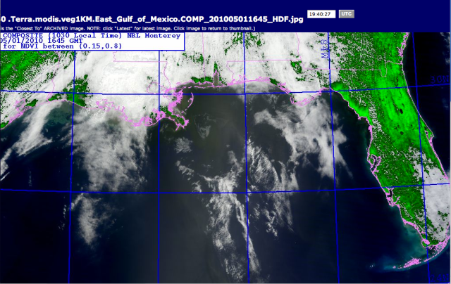
This is what it looked like Saturday, May 1st. I took a satellite picture from the NRL Monterey of the Gulf of Mexico that was showing biological substances, cropped it, and color enhanced it by playing with the settings on iphoto, to make the colors have more contrast. Since oil is based on organics, this made it show up better, and I could recreate, roughly, what the LSU ESL was doing to get the oil to show up on their pictures I posted previously. Because there were thunderstorms this past weekend, the area was obscured by cloud cover often. I also noticed the government was not putting up daily picture updates.
May 1, 2010 BP Deepwater Horizon’s oil slick in the Gulf of Mexico, photo NRL Monterey, color enhanced by ARC The thicker part of the slick is the part that looks like a bird’s beak pointing upside down off the New Orleans Louisiana Delta, which is to the left in green and pink. Pink is the coastline, drawn in. The greenish tint is where the slick is thinner. The blue is the water.
*
*
This is the same picture from May 1st, larger area, without my increasing the color contrast.
May 1, 2010, BP Deepwater Horizon’s Oil slick in the Gulf of Mexico, photo NRL Monterey. The heavier part of the slick is gray, the lighter part of the slick is very hard to see, but is there and greenish grey. The coast outline is drawn in pink by the website. The ^ triangle to the north in the shoreline is the Bay of Mobile, Alabama. To find the origin of the slick, look down from the left side of that triangle of the Mobile Bay and come out from the Delta about at a 45º degree angle, where the lines would meet, is roughly where the broken drill rig is. Where the up and down brilliant blue longitude line is to the right touches shore, is where Pensicola Bay is in the Florida panhandle.
*
*
As you can see from this larger view, the slick actually has spread quite a bit towards the Florida Panhandle by Saturday the 1st.

5/1/2010, Larger view of Gulf with BP DH Oil slick southwest of the New Orleans delta, spreading towards Alabama and Florida.
*
*
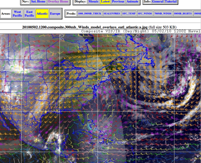
Sunday May 2- This lovely overlay picture below is the satellite of the eastern half of the US, including the gulf of Mexico, with the wind direction and speed marked on it. Think of the little color icons as brooms with the stick end pointing towards what way the wind is going, and the bigger the broom, the faster. There were several thunderstorm fronts moving thru to the southeast, and the wind in the Gulf is spinning in a clockwise manner, driving the waves and the oil around and around and easterly at the same time.
This is known as the “Conveyer Belt.” photo NRL Monterey

Wind Direction on Sunday the 2nd, showing the Gulf’s classic “Conveyor Belt.”
The other thing you can see here is a big low pressure system spinning off the eastern coast and it’s spinning counterclockwise. Look at Florida. Now look at Cuba, the long island under it, then to its right, the island with Haiti and the Dominican Republic, and to the right of that, little bitty Puerto Rico, the rectangle island.
Do you see how small Puerto Rico is ? Do you see how big the oil slick is, in the first picture ? Do you know how stupid White House Correspondent Cokie Roberts looked, prattling about how the oil slick is so big it was as big as Puerto Rico, all day Saturday, when she wasn’t blathering about the White House Correspondent’s dinner ?
May 04 2010
May 02 2010
By Dan Swenson, New Orleans Times-Picayune
This animation of the Gulf of Mexico oil spill was created using actual overflight information and forecast models from the NOAA and Unified Command.
The red dot is the location of the Deepwater Horizon oil well, which exploded on April 20, releasing oil into the Gulf near the Louisiana coast that has yet to be contained. Eleven rig workers are missing and are presumed to have died in the explosion.
The animation begins April 22, the day the first image of the spill via flyover was released.
All Antemedius stories about BP’s Deepwater Horizon Gulf of Mexico spill are here.