Remember Blue Popsicles ?
The Pipes on the Outhouse Froze. photo, Navy. color, ARC.

May 09 2010
May 05 2010
Today is Tuesday, May the 4th, the 2 week anniversary of the blowout, fire, and sinking of the BP Deepwater Horizon oil drilling rig in the Gulf of Mexico. 14 days x 5000 barrels per day, = 70,000 barrels, or 2,940,000 gallons of oil so far have been dumped into the Gulf. For my earlier diary today, with satellite photos from the past weekend, go here:
This Oil Spill is Bigger Than Delaware, You Idiots!
There are new satellite pictures from today which show the spread of the oil slick has continued west and south.
May 04 2010
The BP Deepwater Horizon drilling rig failed on Tuesday evening April 20, 2010, 14 days ago.
This is what it looked like Saturday, May 1st. I took a satellite picture from the NRL Monterey of the Gulf of Mexico that was showing biological substances, cropped it, and color enhanced it by playing with the settings on iphoto, to make the colors have more contrast. Since oil is based on organics, this made it show up better, and I could recreate, roughly, what the LSU ESL was doing to get the oil to show up on their pictures I posted previously. Because there were thunderstorms this past weekend, the area was obscured by cloud cover often. I also noticed the government was not putting up daily picture updates.
May 1, 2010 BP Deepwater Horizon’s oil slick in the Gulf of Mexico, photo NRL Monterey, color enhanced by ARC The thicker part of the slick is the part that looks like a bird’s beak pointing upside down off the New Orleans Louisiana Delta, which is to the left in green and pink. Pink is the coastline, drawn in. The greenish tint is where the slick is thinner. The blue is the water.
*
*
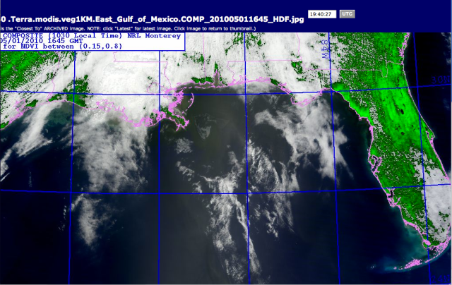
This is the same picture from May 1st, larger area, without my increasing the color contrast.
May 1, 2010, BP Deepwater Horizon’s Oil slick in the Gulf of Mexico, photo NRL Monterey. The heavier part of the slick is gray, the lighter part of the slick is very hard to see, but is there and greenish grey. The coast outline is drawn in pink by the website. The ^ triangle to the north in the shoreline is the Bay of Mobile, Alabama. To find the origin of the slick, look down from the left side of that triangle of the Mobile Bay and come out from the Delta about at a 45º degree angle, where the lines would meet, is roughly where the broken drill rig is. Where the up and down brilliant blue longitude line is to the right touches shore, is where Pensicola Bay is in the Florida panhandle.
*
*
As you can see from this larger view, the slick actually has spread quite a bit towards the Florida Panhandle by Saturday the 1st.

5/1/2010, Larger view of Gulf with BP DH Oil slick southwest of the New Orleans delta, spreading towards Alabama and Florida.
*
*
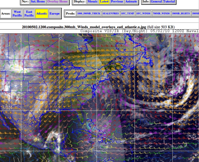
Sunday May 2- This lovely overlay picture below is the satellite of the eastern half of the US, including the gulf of Mexico, with the wind direction and speed marked on it. Think of the little color icons as brooms with the stick end pointing towards what way the wind is going, and the bigger the broom, the faster. There were several thunderstorm fronts moving thru to the southeast, and the wind in the Gulf is spinning in a clockwise manner, driving the waves and the oil around and around and easterly at the same time.
This is known as the “Conveyer Belt.” photo NRL Monterey

Wind Direction on Sunday the 2nd, showing the Gulf’s classic “Conveyor Belt.”
The other thing you can see here is a big low pressure system spinning off the eastern coast and it’s spinning counterclockwise. Look at Florida. Now look at Cuba, the long island under it, then to its right, the island with Haiti and the Dominican Republic, and to the right of that, little bitty Puerto Rico, the rectangle island.
Do you see how small Puerto Rico is ? Do you see how big the oil slick is, in the first picture ? Do you know how stupid White House Correspondent Cokie Roberts looked, prattling about how the oil slick is so big it was as big as Puerto Rico, all day Saturday, when she wasn’t blathering about the White House Correspondent’s dinner ?
Apr 30 2010
The wind forecast for today in the Gulf of Mexico near New Orleans, Louisiana, is from the southeast.
http://forecast.weather.gov/Ma…
Map of April 30 2010 Friday forecast of the BP Oil spill trajectory, in tan. Other days shown in other colors. Black asterisk at lower tip of light blue shows location of broken Deepwater Horizon well in the Gulf of Mexico. Image courtesy of NOAA
Apr 25 2010
In oceania, no one can hear you seep.
The U.S. Coast Guard “discovered” 4 days after an explosion destroyed and sank the Deepwater Horizon drilling rig 40 miles off the coast of Venice, Louisiana, killing 11 crew workers, that indeed, oil does appear to be leaking out of the well head on the floor of the ocean.
From HuffPo this morning:
http://www.huffingtonpost.com/…
“We thought what we were dealing with as of yesterday was a surface residual (oil) from the mobile offshore drilling unit,” (Rear Admiral Mary) Landry said. “In addition to that is oil emanating from the well. It is a big change from yesterday … This is a very serious spill, absolutely.”Coast Guard and company officials estimate that as much as 1,000 barrels – or 42,000 gallons – of oil is leaking each day after studying information from remotely operated vehicles (underwater) and the size of the oil slick surrounding the blast site. The rainbow-colored sheen of oil stretched 20 miles by 20 miles on Saturday – about 25 times larger than it appeared to be a day earlier, Landry said.
BP PLC, which leased the rig and is taking the lead in the cleanup, and the government have been using the remotely operated vehicles to try to stop the leak by closing valves on the well deep underwater. If that doesn’t work, the company could drill what’s called an intervention well to control the oil flow. But the intervention drilling could take months.
The article says that the 1989 Exxon Valdez tanker wreck in Alaska was 11 million gallons. By dividing 11 million by 42,000 gallons, assuming the government is not lowballing this estimated amount, which seems like a nice, suspiciously round number, “1000 barrels,” I’m coming up with 261 days before this is as big as the Exxon Valdez spill. The regional director for the Federal government’s Mineral Management Services (the wonderful folk who let the companies bid on offshore drilling tracts) says that leaks have been repaired at this depth before, but it is difficult. Bad weather is currently delaying the cleanup of already spilt oil.