Tag: Sealing cap

BP Gone Fishin’- Drops Giant Pipe Into Seafloor, Manages to Miss Wellhead- Yay Team!

This video courtesy of the BP live webcam addicts at the Oil Drum.  http://www.theoildrum.com/node…

When we last left our ongoing story of why The Brightest Minds in Govt. Science were giving BP permission to keep  ****ing around playing with their broken oil well, instead of completing the Bottom Kill cementing, BP was observed to be moving Giant Tools towards the Macondo 252 Deepwater Horizon oil well again, then Adm. Allen had to give out matching narrative after a few news cycles as to what the fooking h*ll they were really doing.

We’ll do the bottom kill when we’re ready, Harry.  – Adm. Thad “Patton” Allen  

They wanted to look inside the old BOP, and go fishing and pull the old drill pipe out of the well bore. Bottom kill, schmottom kill, the Lawyers need evidence to sue each other for the next 2 decades.

So far, they took the very top lid off the new BOP and Stacking Ram they mounted on the old one,  and peered inside, and noticed that the brand new BOP and 3 blade Stacking Ram had 1 Shear Ram that was stuck in a half open, half shut position so they couldn’t get down and look into the other parts.

Yes, their brand new BOP toy wasn’t working already.

Okay.  No problemo.  Just spend a week trying to jimmy the the thing open again.  

BP Friday: Did You Remember to Flush Before Glossing ?

Because the Original is always so much better than anything I could ever hope to make up:

The Further Adventures of Macondo 252, Oil Well of Doom

Hit the theme music:

If I had to do the same again, I would, my friend, Fernando !  

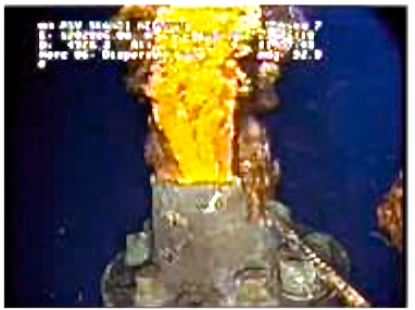
Remember this, back in June on the 23rd ?

BP oil spill,riser pipe,BOP stubb,drill ship,Discover Enterprise,Discoverer Enterprise Gas Flare,Methane Gas Flair

Uncapped BP Well before installation of new blow out protector assembly.

And then in July, they finally got a new spool, cap n stack and a spankin’ new Blow Out Protector on the thing to cap the well and shut it off almost 3 months after it blew ?  And everybody went Halleleujah ?

BP Bottom Kill Stalled Out During Shrimp Cocktail Party Season

You are so going to love this.  Another in the series, Macondo, Oil Well of Doom.

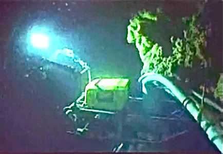
I have wrestled an image from the balko puter onto photomucket.  Look what I found on the BP webcams this evening.

BP oil spill,bop tool

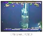
What the bleep is this on Rov Enterprise 2 cam  Tues evening Aug 17th ?

Check the official BP twitter feed.  http://twitter.com/BP_America    

As part of a #BP tourism grant, Gulf resort giving free night’s stay and $250 gift card: http://bit.ly/bV9XKC

about 4 hours ago via HootSuite

Retweeted by 5 people

BP_America

http://twitter.com/BP_America/…

That’s not a Motel 6.  WTF.    

Friday:Couldn’t Even Wait for the Cement to Cure

This week in Trickle Down Oilonomics:

First, remember this ?

Riser Pipe Cut,BP oil spill,BOP plume   Screen shot from June 1, 2010 of ROVs cutting the old riser pipe off the old top of the BOP, showing the underwater plume.

Two months later:

Tues,  Aug 3, 2010,  BP pumped drilling mud into the capped Macondo 252 Deepwater Horizon well from the top.

http://www.bp.com/genericartic…

BP announces Static pressure stabilization from  Mud Pump into well a success on Wed Aug 4th.

http://www.usatoday.com/news/n…

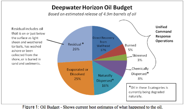
Federal Government and NOAA’s Lubchenco & team of expert scientists announce rest of oil in Gulf of Mexico is naturally biodegrading. Oil is disappeared !    As of Wed, Aug 4th.  https://www.docudharma.com/diar…

BP oil spill,pie chart,Oil budget calculator tool,oil all gone pie chart by NOAA

From Plume to Pie Chart, 6/1/2010 to 8/4/2010.  In Amerika, Oil Spill Cleans You !  

Except that 650 miles of shoreline in Louisiana, Mississippi, Alabama, and Florida remained oiled, and 57,539 square miles, or 24% of the Gulf of Mexico, is closed to fishing, per their own press release.  http://ht.ly/2loZg

BPravda Today

BPravda Today

Macno Nc4e3aet !

BP oil spill,pie chart,Oil budget calculator tool,oil all gone pie chart by NOAA

Wednesday, August 4, 2010

Because the original documents are always so much better than anything I could hope to make up:

http://ht.ly/2kWkj


August 4, 2010, Gulf of Mexico Oil Spill Response, Deepwater Horizon Incident Joint Information Center

Federal Science Report Details Fate of Oil from BP Spill

WASHINGTON – The vast majority of the oil from the BP oil spill has either evaporated or been burned, skimmed, recovered from the wellhead or dispersed using chemicals –  much of which is in the process of being degraded. Much of this is the direct result of the federal response efforts.

A third (33 percent) of the total amount of oil released in the Deepwater Horizon/BP spill was captured or mitigated by the Unified Command recovery operations, including burning, skimming, chemical dispersion and direct recovery from the wellhead, according to a federal science report released today.

An additional 25 percent of the total oil naturally evaporated or dissolved, and 16 percent was dispersed naturally into microscopic droplets.  The residual amount, just over one quarter (26 percent), is either on or just below the surface as residue and weathered tarballs, has washed ashore or been collected from the shore, or is buried in sand and sediments.  Dispersed and residual oil remain in the system until they degrade through a number of natural processes.  Early indications are that the oil is degrading quickly.

These estimates were derived by the National Oceanic and Atmospheric Administration (NOAA) and the Department of the Interior (DOI), who jointly developed what’s known as an Oil Budget Calculator, to provide measurements and best estimates of what happened to the spilled oil.   The calculator is based on 4.9 million barrels of oil released into the Gulf, the government’s Flow Rate Technical Group estimate from Monday. More than 25 of the best government and independent scientists contributed to or reviewed the calculator and its calculation methods.

“Teams of scientists and experts have been carefully tracking the oil since day one of this spill, and based on the data from those efforts and their collective expertise, they have been able to provide these useful and educated estimates about the fate of the oil,” says Jane Lubchenco, under secretary of commerce for oceans and atmosphere and NOAA administrator.  “Less oil on the surface does not mean that there isn’t oil still in the water column or that our beaches and marshes aren’t still at risk.  Knowing generally what happened to the oil helps us better understand areas of risk and likely impacts.”

The estimates do not make conclusions about the long-term impacts of oil on the Gulf.  Fully understanding the damages and impacts of the spill on the Gulf of Mexico ecosystem is something that will take time and continued monitoring and research.

Dispersion increases the likelihood that the oil will be biodegraded, both in the water column and at the surface.  While there is more analysis to be done to quantify the rate of biodegradation in the Gulf, early observations and preliminary research results from a number of scientists show that the oil from the BP Deepwater Horizon spill is biodegrading quickly.  Scientists from NOAA, EPA, DOE, and academic scientists are working to calculate more precise estimates of this rate.

It is well known that bacteria that break down the dispersed and weathered surface oil are abundant in the Gulf of Mexico in large part because of the warm water, the favorable nutrient and oxygen levels, and the fact that oil enters the Gulf of Mexico through natural seeps regularly.

Residual oil is also degraded and weathered by a number of physical and biological processes.  Microbes consume the oil, and wave action, sun, currents and continued evaporation and dissolution continue to break down the residual oil in the water and on shorelines.

The oil budget calculations are based on direct measurements wherever possible and the best available scientific estimates where measurements were not possible.  The numbers for direct recovery and burns were measured directly and reported in daily operational reports.  The skimming numbers were also based on daily reported estimates.  The rest of the numbers were based on previous scientific analyses, best available information and a broad range of scientific expertise.  These estimates will continue to be refined as additional information becomes available.

BP oil spill,texas coast,achalafalay bay

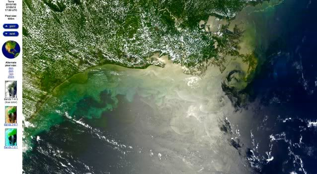
7/9/2010 Gulf of Mexico  6 days before the leaking well was capped. photo NASA

67% of this is going to go away all by itself, naturally, according to the finest scientific minds available. Image from NOAA and the Deepwater Horizon Incident Joint Information Center.

Senate Performs Successful Top Kill For BP

This is going to be a mish mash of various links relevant to today’s oil spill news, Tues Aug 3, 2010.  I took one look at the amusing picture of the moonshine still on the open thread and saw instead the Blow Out Protector on the Macondo Oil Well of Doom.

I was trying not to laugh my arse off about a certain fp diary at a certain blog yesterday which was a repeat of a certain breathless Washington Post article announcing that The Oil Spill Was Really BIGGER than they all thought according to the “new” government figures.

Which was as big as the government knew all along, from April 23, 3 days after the blowout, when they were doing estimates based on BP’s internal documents that weren’t released yet, and then the government and BP have colluded since then to lie their a$$es off about.   NOAA released a chart of the potential leak impact on the coast line back in April with the higher number.

3 months minus 5 days times 50,000 to 60,000 barrels a day.  Duh.  As if BP Tony hadn’t mentioned 60,000 a day back in June in front of Congress, either.

Yes, they really do think we are THAT stupid.

BP Oil Well to be CAPPED during Weather Evacuation

For the past several days, everyone has been speculating on what would be done with the unfinished relief wells and new but ever so slightly oozing sealing cap and 3 ram stack assembly,  should the relatively calm Gulf coast weather turn on them.   Today’s the one week anniversary of the BP oil well successfully being turned off.

Previously no decision had been made, with hints that the well might have to be opened up again, if they had to abandon the Macondo Canyon 252 site because of a hurricane or tropical cyclone.

Per Admiral Thad Allen’s latest press briefing this afternoon, ongoing, they are planning to leave the broken BP oil well capped if they have to evacuate the area because of an oncoming weather system.    

http://twitter.com/BP_America/…

The relief well that is farther along, and only about 4 feet horizontally from intersecting the old Deepwater Horizon wellbore, with just a bit of casing to put in at the very end for the last 100 feet they still have to drill,  has received a temporary plug, called a “storm packer ”   which they stuff down it 300 feet below the sea floor.

Picture of the storm packer plug here: http://www.theoildrum.com/node…

gulf of Mexico storm,storm,tropical depression,tropical depression #3,storm Bonnie

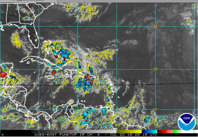
Tropical Depression #3, not looking real organized yet.

Here’s the storm that will be named “Bonnie” if it gets organized.  Right now, Bonnie is still Tropical Depression #3 with a “high” aka 50% or greater, probability of going to cyclone status within 48 hours, and a projected storm track to head possibly for the Louisiana Delta.   T.D. #3 is over land right now, which is keeping it milder.  http://www.nhc.noaa.gov/gtwo_a…

Here’s a live, updating, easy to load satellite link to watch “Bonnie to Be” which is currently the leading edges on the very right hand side of this image, Thurs, July 22, at 1:35 pm PDT.   ( pic was taken 2:45 pm local )

http://www.ssd.noaa.gov/goes/e…

Here’s that NOAA cafeteria page of every possible weather graphic you’d ever want to see for New Orleans/Baton Rouge, loads more slowly   http://www.srh.noaa.gov/lix/?n…

New Cap for Leaking Oil Well as Slick Blows Towards Texas, & More Alaska Drilling

Just when you thought we were up to our a$$es in oily alligators,  the Obama Administration Department of the Interior announces plans to open 1.8 million acres of Alaska’s National Petroleum Reserve to bidding on 190 new tracts for NEW OIL AND GAS DRILLING.   Bidding will open Aug 11.

Gotta Love Grist. Called it The Dept of Not Learning.      http://www.grist.org/article/2…

It’s only another 1.8 million acres.

http://interior.gov/news/press…

Increases number of oil/gas wells by 60% from 310 to 500.

Increases number of acres under drilling  by 60% from 3 million  to 4.8 million

Teshekpuk Lake is 80 miles east of Point Barrow on the northern Alaska coastline, which is already being damaged by the warming climate and melting arctic sea ice.  Up to 90,000 geese use the area to molt every summer, and the Indigenous people use part of the local caribou herd to survive by subsistence hunting.

http://en.wikipedia.org/wiki/T…

____

The BP Oil Slick is Blowing Towards Texas.  Here’s the satellite image from NASA, Friday, July 9th,  from 1 km up in space

http://rapidfire.sci.gsfc.nasa…

BP oil spill,texas coast,achalafalay bay

Friday, July 9, 2010.  Oil slick heads west towards Texas coast. photo NASA

BP oil spill,yucatan penninsula,texas coast,achalafalay bay

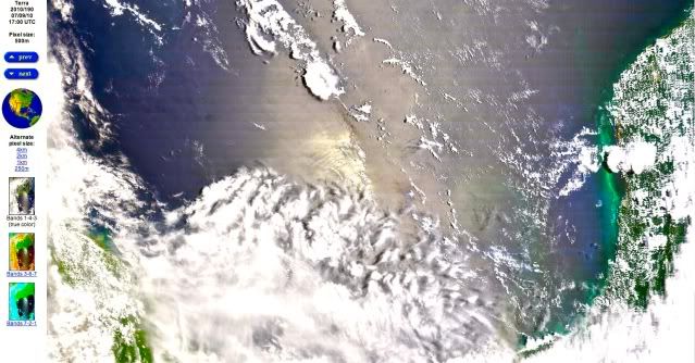
Oil Slick now extends south all the way to the east of the Yucatan Peninsula in Mexico.  This is the bottom half of the same image of the Gulf of Mexico on 7/9/10 as above. photo NASA

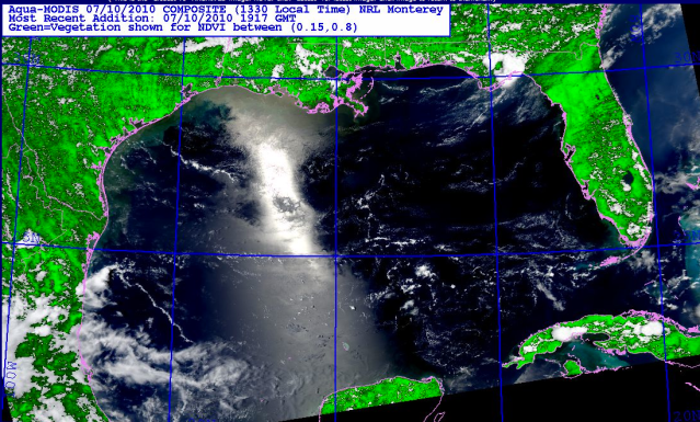
photo from today, Saturday July 10, 2010

Gulf,BP Oil Spill,texas coastline,nature,tragedy

Today, July 10, 2010, Gulf of Mexico.  Winds are now shifting to come out of the west/southwest again after an east wind drove this oil towards Texas earlier this week.    But the oil to the south near the Yucatan peninsula,  is probably going to continue to go west, then north again,  with the natural Gulf clockwise current.   photo, NRL Monterey, biomass, satellite Aqua