Tag: Permafrost

TBC: Morning Musing 3.3.15

I have 4 articles on a common theme for ya this morning!

First, TransCanada is using eminent domain to seize land, and all those property rights folks on teh right are strangely silent, go figure:

TransCanada Is Seizing People’s Land To Build Keystone, But Conservatives Have Been Dead Silent

Crawford, who lives in Direct, Texas, had been trying since 2011 to keep the pipeline company off her property. But she ultimately lost, the portion of her land needed for the pipeline condemned through eminent domain – a process by which government can force citizens to sell their property for “public use,” such as the building of roads, railroads, and power lines. Crawford can’t wrap her head around why TransCanada, a foreign company, was granted the right of eminent domain to build a pipeline that wouldn’t be carrying Texas oil through the state of Texas.

That question – how eminent domain can be used in a case like Keystone – has some anti-Keystone groups stumped too. But the groups that usually are vocal proponents of property rights, including the Institute for Justice, have been silent when it comes to the controversial pipeline.

“I have not seen a single group that would normally rail against eminent domain speak up on behalf of farmers or ranchers on the Keystone XL route,” said Jane Kleeb, founder of the anti-Keystone group Bold Nebraska.

That’s surprising to Kleeb, whose organization is supporting the efforts of a group of Nebraska landowners along the pipeline’s proposed route who have held out against giving TransCanada access to their land. She had thought that at least a few conservative or pro-lands rights groups would have voiced their general support for Keystone XL, but still denounced the use of eminent domain to get it built. That hasn’t happened, Kleeb said – not among property rights groups nor among most pro-Keystone lawmakers.

“If this were a wind mill project or a solar project, Republicans would have been hair-on-fire crazy supporting the property rights of farmers and ranchers,” she observed. “But because it’s an oil pipeline, it’s fine.”

Jump!

New Cap for Leaking Oil Well as Slick Blows Towards Texas, & More Alaska Drilling

Just when you thought we were up to our a$$es in oily alligators,  the Obama Administration Department of the Interior announces plans to open 1.8 million acres of Alaska’s National Petroleum Reserve to bidding on 190 new tracts for NEW OIL AND GAS DRILLING.   Bidding will open Aug 11.

Gotta Love Grist. Called it The Dept of Not Learning.      http://www.grist.org/article/2…

It’s only another 1.8 million acres.

http://interior.gov/news/press…

Increases number of oil/gas wells by 60% from 310 to 500.

Increases number of acres under drilling  by 60% from 3 million  to 4.8 million

Teshekpuk Lake is 80 miles east of Point Barrow on the northern Alaska coastline, which is already being damaged by the warming climate and melting arctic sea ice.  Up to 90,000 geese use the area to molt every summer, and the Indigenous people use part of the local caribou herd to survive by subsistence hunting.

http://en.wikipedia.org/wiki/T…

____

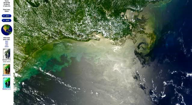
The BP Oil Slick is Blowing Towards Texas.  Here’s the satellite image from NASA, Friday, July 9th,  from 1 km up in space

http://rapidfire.sci.gsfc.nasa…

BP oil spill,texas coast,achalafalay bay

Friday, July 9, 2010.  Oil slick heads west towards Texas coast. photo NASA

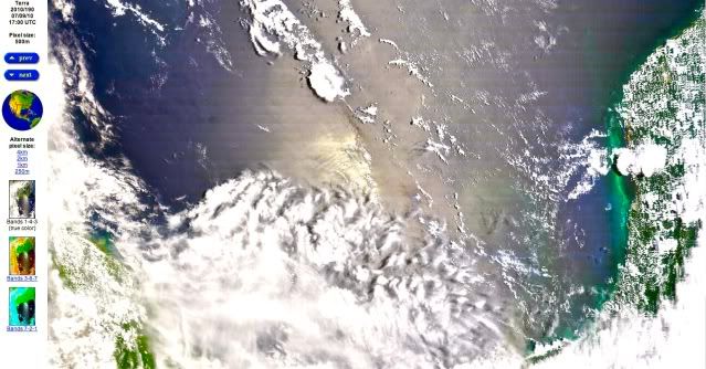
BP oil spill,yucatan penninsula,texas coast,achalafalay bay

Oil Slick now extends south all the way to the east of the Yucatan Peninsula in Mexico.  This is the bottom half of the same image of the Gulf of Mexico on 7/9/10 as above. photo NASA

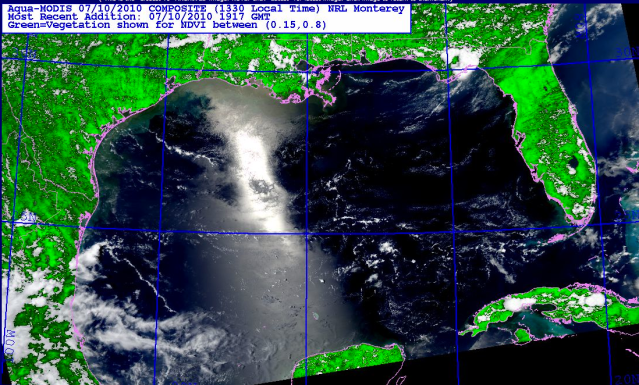
photo from today, Saturday July 10, 2010

Gulf,BP Oil Spill,texas coastline,nature,tragedy

Today, July 10, 2010, Gulf of Mexico.  Winds are now shifting to come out of the west/southwest again after an east wind drove this oil towards Texas earlier this week.    But the oil to the south near the Yucatan peninsula,  is probably going to continue to go west, then north again,  with the natural Gulf clockwise current.   photo, NRL Monterey, biomass, satellite Aqua